
Last modified: 2021-08-26 by  klaus-michael schneider
Keywords: colombia |
Links: FOTW homepage |
search |
disclaimer and copyright |
write us |
mirrors
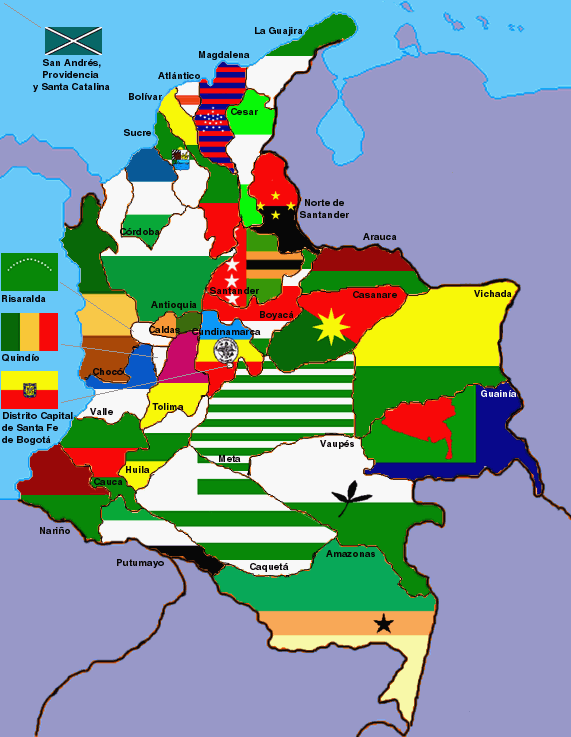
image by Antonio Broto, 12 July 2001
See Also:
Other Sites:
According to the 1991 Political Constitution of Colombia, the
current tittle for the formerly Intendencias and Comisareas is
Departamentos. this is only a type of territorial entities now.
Mario de la Calle Lombana, 26 September 1999
The Departaments and Capitals are:
Andes Region (Región Andina) - Major City in
this Region: Santafé de Bogota
- Nariño/Pasto (San Juan de Pasto)
- Cauca/Popayan
- Valle del Cauca
- Huila/Neiva
- Tolima/Ibagué
- Quindio/Armenia
- Risaralda/Pereira
- Caldas/Manizales
- Cundinamarca/Bogotá (Santafé de Bogotá D.C.)
- Boyacá/Tunja
- Santander/Bucaramanga
- Norte de Santander/Cucutá (San José de Cucutá)
- Antioquia/Medellín
Caribbean Región (Región Caribe) - Major
City in this Region: Barranquilla
- Córdoba/Montería
- Sucre/Sincelejo
- Cesar/Valledupar
- Bolívar/Cartagena (Cartagena de Indias)
- Atlántico/Barranquilla
- Magdalena/Santa Marta
- La Guajira/Riohacha
The Pacific Región (Región Pacifica):
The Western Part of Western Mountains of Departamen of Valle del
Cauca, Nariño and Cauca are Part of Pacific Región. Mjor City
in this Region: Buenaventura, Valle del Cauca
-Chocó/Quibdó (Quibdo)
Orinoquia Region (Región Orinoquía) a.k.a
"Llanos Orientales" ( Eastern Plains) - Major City in
this Region: Villavicencio:
- Meta/Villavicencio
- Casanare/Yopal
- Vichada/Puerto Carreño
- Arauca/Arauca
Amazon Region (Región Amazonia) - Major City
in this Region: Florencia, Caqueta:
- Amazonas/Leticia
- Putumayo/Mocoa
- Caquetá/Florencia
- Guaviare/San José del Guaviare
- Vaupés/Mitú (Mitu)
- Guainía/Puerto Inirida (ex-Puerto Obando)
Insular Region (Región Insular)
- San Andrés, Providencia and Santa Catalina
- Minor outlying islands
The Constitution of 1991 had created Metropolitan Areas:
- Metropolitan Area of Aburra Valley "Medellin"
(Medellín - Barbosa - Bello - Caldas - Copacabana - Envigado -
Girardota - Itagui - La Estrella-Sabaneta) was created ny Decree
038 of 13 January of 1991
- Metropolitan Area of Bucaramanga (Bucaramanga - Floridablanca -
Piedecuesta - Giron)
- Metropolitan Area of Cucuta (Cucuta - Villa del Rosario - El
Zulia - San Cayetano - Los Patios)
- Metropolitan Area of Barranquilla (Barranquilla - Soledad -
Malambo - Puerto Colombia)
- Metropolitan Area of Pereira (Pereira - Dosquebradas - La
Virginia)
There are also 4 Districts:
- District Capital ( Santafe de Bogota)
- Port and Industrial District of Barranquilla
- Tourism and Cultural District of Cartagena ( Cartagena de
Indias )
- Tourism, Cultural and Histrorial District of Santa Marta (In
Santa Marta Simon Bolivar Died).
Felipe Carrillo, 23 July 2002
Colombia create 6 New Districts:
Buenaventura, Tumaco, Turbo, Cucutá, Popayán and Tunja
Felipe Carrillo, 12 January 2008
Currently, according to the 1991 Political Constitution of
Colombia, the country has 32 Departments. The number of Regions
the country officially has is six, according to the IGAC
(Instituto Geografico Agustin Codazzi, Agustin Codazzi
Geographical Institute), the official government entity in charge
of issuing the Official Map of Colombia and its Basic
Cartography, as well as other important tasks.
The Regiones Naturales (Natural Regions), in the order reported
by the IGAC: - Región Andina (Andean Region), named after the
Andes Mountain Range - Región Caribe (Caribbean Region), named
after the Carribbean Sea - Región Pacifica (Pacific Region),
named after the Pacific Ocean - Región Orinoquía (Orinoquia
Region), named after the Orinoco River - Región Amazonia
(Amazonia Region), named after the Amazon River - Región Insular
(Insular Region), name based on the minor outlying islands.
Source: IGAC's
official web site.
E.R., 3 August 2008
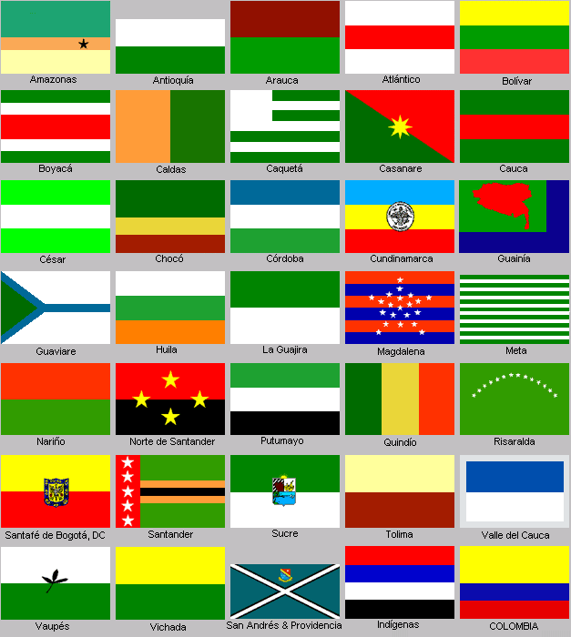
Click here for a set of Colombian departments small flags by Blas Delgado, 6 October 2001
Quita Sueno Bank, Roncador Cay and Serrana Bank
On September 8, 1972, the US and Columbia signed a treaty in
Bogota recognizing Columbia's sovereignty over Quita Sueno Bank,
Roncador Cay and Serrana Bank. The treaty was effective September
17, 1981.
Phil Nelson , 27 April 2000
Claimed by both the United States and Columbia. This is a
series of small cays located approximately 210 miles NNE of
Nicaragua. These islands were originally claimed by the US under
the Guano Act. Columbia considers this part of the Province
Archipelago (San Andrés y Providencia
). Additionally, Honduras appears to have claimed this area as
well.
Phil Nelson , 27 April 2000
Metropolitan Areas in Colombia are officially designated
administrative and census areas, composed of an urban center and
its associated Municipalities. The following criteria must be met
for a group of communities to be designated a Metropolitan Area:
- Each one of the Municipalities, the secondary cities as well as
the central city, must have a population of at least 50,000
inhabitants. - The secondary cities must integrate their city
planning with that of the central city.
- At least two-thirds of those employed in the area must perform
non-rural activities.
- Each of the secondary cities must have at least 10% of their
workers employed in the central city.
- Commuting to work is, in fact, the major characteristic of a
Metropolitan Area. As a result, the secondary cities are often
called "dormitory cities"; meaning places where the
inhabitants only go home to sleep.
An important function of the Metropolitan Areas is to provide for
joint planning between the Municipalities, thereby managing
ordered and proportional economic growth according to the
necessities of the area and the physical characteristics of each
Municipality.
These Areas are stipulated in the most recent Constitution of
Colombia (1991), where in Article 319 it mentions their
establishment. The Areas could be created either by Ley (national
level, issued by Congress or by the President) or by Ordenanza
(Ordinance are the the bills passed through the Department
Legislative body which is called Asamblea, Assembly in English)
These Areas could in turn evolve into Distritos (Districts).
The first districts were created by the 1991 Constitution in
Article 356 and were: Bogotá (Bogotá D.E. for Distrito
Especial, Special District; Barranquilla Distrito Especial
Industrial y Portuario (Special Industrial and Port District),
Cartagena Distrito Turístico (Cultural District) and Santa Marta
Distrito Turístico Cultural e Histórico (Cultural Tourism and
Historic District). However Acto de Reforma Constitucional No. 02
(Constitutional Reform Act No. 02 of July 7, 2007) changed the
Constitution and included as districts the following: Cúcuta
Distrito Especial Fronterizo Y Turístico (Special Border and
Turistic District), Popayan Distrito Especial Histórico,
Universatario y Ecoturistico (Special Historic, University and
Ecotouristical District), Tunja Distrito Cultural y Turítico
(Cultural and Historic District) , Buenaventura Distrito Especial
(Special District), Turbo Distrito Especial Portuario de Urabá
(Port Special District of Uraba) and Tumaco Distrito Especial
Portuario (Special Port District) .
The following are current Metropolitan Areas recognized by the
Colombian government (in order of establishment). The firs
Municipality in an Area is the main city (also the Capital of the
Department) and the rest are the surrounding and conurban
Municipalities:
- Área Metropolitana del Valle de
Aburrá (Metropolotian Area of the Aburra Valley), Created by
Ordenanza No. 34 of Nov. 20 de 1980 and regulated by Law No. 128
of 1994, and Law No. 99 of 1993. Composed of Medellín, Bello,
Barbosa, Copacabana,
La Estrella, Girardota,
Itagüí, Envigado,
Caldas and Sabaneta.
Official website at:<www.metropol.gov.co>.
- Área Metropolitana de Bucaramanga (Metropolitan Area of
Bucaramanga). Created by Ordenanza No. 20 of 1981. Composed of Bucaramanga, Floridablanca
and Girón. In 1986, the newly
incorporated Municipality of Piedecuesta
was added. Official website at: <www.amb.gov.co>.
- Área Metropolitana de Barranquilla (Metropolitan Area of
Barranquilla). Created by Ordenanza No. 28 of 1981. Composed of Barranquilla, Puerto
Colombia , Soledad, Malambo and Galapa.
Official website at: <www.ambq.gov.co>.
- Área Metropolitana de Cúcuta (Metropolitan Area of Cúcuta).
Created by Decree 000508 of 1991. Composed of Cúcuta, Villa
del Rosario, Los Patios and El Zulia. Official website at: <www.areametrocucuta.gov.co>.
- Área Metropolitana de Centro Occidente (Metropolitan Area of
the Midwest). Created by Ordenanza No. 014 of 1991. Composed of Pereira and Dosquebradas.
La Virginia was added after its
incorporation and Santa Rosa de Cabal
is waiting to be approved. Official website at: <www.amco.gov.co>.
- Área Metropolitana de Valledupar (Metropolotian Area of
Valledupar): Created in 2005. Composed of Valledupar, Agustín
Codazzi, La Paz, Manaure and San
Diego. Official website at: <www.valledupar.gov.co>.
There are also several Metropolitan Areas geographically defined,
but not legally established nor recognized (see wikipedia).
Notice that in a Metropolitan Area the main city is usually a
District as the main Hub.
E.R., 18 February 2010