 image by Bruce Berry, 17 July 2008
Last modified: 2022-02-12 by bruce berry
Keywords: nieuwe republiek | vrijheid |
Links: FOTW homepage |
search |
disclaimer and copyright |
write us |
mirrors
![[Nieuwe Republiek (South Africa)]](../images/z/za-bnr.gif) image
by António Martins, 02 Mar 1999
See also :
image
by António Martins, 02 Mar 1999
See also :
 image by Bruce Berry, 17 July 2008
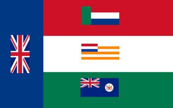
The version approved by the Volksraad (People's Assembly) on 13 November 1884 specified that miniature flags should be placed on each of the stripes - thus the Union Jack was added to to blue vertical stripe, the Vierkleur was added to the red stripe, the Orange Free State Vierkleur was added to the white stripe and the Cape Colony ensign was added on the green stripe. In The South African Flag Book (2008), Burgers [bur05] makes the point that there is no evidence that this over-complicated design was ever made or flown.
What is interesting is that this is the first example of where 'flaglets'
from various regions of South Africa were added to a flag and this may have been
a factor in the design of the South Africa national flag in 1927 when flaglets
were added to the white stripe to represent the provinces which had come
together to form the Union of South Africa in 1910.
Bruce Berry, 17 July 2008
Your map of South Africa shows the Nieuwe Republiek as not quite touching
the Zuid-Afrikaansche Republiek (ZAR). They were in fact adjacent and as mentioned
above,
it became part of the ZAR and in 1903 part of Natal. The Colony had claimed
the Nieuwe Republiek as war reparations. What had confused me over the
Nieuwe Republiek was the war reparations received by Natal
in 1903, which comprised the districts of Utrecht and Vryheid. This part
of the map was very familiar to me, and I knew
that these districts had previously been part of the Zuid
Afrikaansche Republiek. What I had not realised was that while the
Vryheid district had been the Nieuwe Republiek and had become part of the
ZAR when the Nieuwe Republiek dissolved itself, the Utrecht district had
been part of the ZAR for much longer. Utrecht was a small early Boer republic
which was at first not recognised by the other Boer states on the grounds
of fear that the British would regard it as an encroachment on their territory.
However, the Lydenburg republic eventually not only recognised it but incorporated
it, and when Lydenburg, Potchefstroom and Zoutpansberg combined to form
the ZAR, Utrecht became part of that state.
Mike Oettle, 14 Dec 2001
Tonight I came across this passage from the Standard Encyclopædia
of Southern Africa:
"After Dinizulu, successor to Cetshwayo, who had died in 1884, had
appealed in van to the British against Usibepu (Zibhebhu), a rival chieftain, he turned to the Boers. Several hundred farmers from
the districts of Utrecht and Vryheid undertook to restore order, in return for land for the formation of an independent republic.
They claimed about half of Zululand, including St Lucia Bay, an outlet to the sea. After considerable dispute a Natal arbitration
court recognised the New Republic, reduced in size, however, and deprived of its claims to St Lucia. The following year
it was absorbed into the Transvaal and the distruct of Vryheid."
This is the only reference I have come across so far to a Boer state
in Zululand, and it comes back to the Nieuwe Republiek, as you see. But it is possible that they used the yellow-green-red flag
during the initial period when they claimed St Lucia Bay. On the other hand it is possible that Usachev was indulging in a bit
of pro-Boer propaganda, publicising the flag of a non-existent state.
Mike Oettle, 14 Jul 2002