
Last modified: 2025-01-25 by zoltán horváth
Keywords: hungary | baranya | baranja | baranya-baja republic | baja | backa |
Links: FOTW homepage |
search |
disclaimer and copyright |
write us |
mirrors
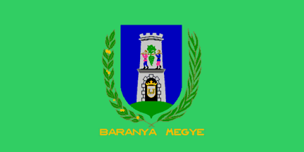
image by Mello Luchtenberg, 9 April 2001
See also:
Baranya county has 10 districts, 301 settlements, including 13 towns, 3 municipalities and 1 city.
City (county seat):
Towns:
Other localities in FOTW:
Res. No.6/1991.(V.31.) of the County about its symbols at <www.bmonk.pecs.hu>.
The inscription is in gold (10th paragraph).
Istvan Molnar, 9 April 2001
The Coat of Arms of Baranya county (Comitatus Baraniensis) was
granted by King Leopold in 1694. The seal was renewed by King
Ferdinand in 1838 and the inscription became Hungarian. Like
Fejer county. The shield was silver originally. The L and I
letters on the small silver shield relate to the King Leopold and
King Joseph (Habsburg). The tower relates to the border [between
Hungary and Croatia or Sclavonia?]. The two people on the tower
is from the Bible (in Hungarian "Jozsue es
Kaleb")
The territory of Baranya before the Treaty of Trianon (1920) was
5.177 km2. The treaty is divided it. 1.136 km2 got to Yugoslavia
(now Croatia), 4.0412 stayed in Hungary.
Source: Hoppal Dezso: A tortenelmi Magyarorszag
varmegyeinek cimerei, Bp. 2001 (The Coat of Arms of the counties
of the historical Hungary)
Istvan Molnar, 9 April 2001
I am not sure to what border the tower might relate. It may be
as Istvan suggested the border of Hungary with Croatia and
Slavonia. It was the Croatian king Tomislav that "pushed
out" the Hungarians "over the Drava river" (Drava
running along the whole south edge of historical Baranya) in
early 10th century, and the border on Drava was then established
as the border among the two nations. However, in the time when
the CoA was granted the two nations were under the same rule and
this then already historical border was maybe not so important.
In 17th century the border was that one against the Turk
(Ottoman) empire. Still it took almost a hunderd years after the
king Leopold granted the arms that the Slavonia to the south was
librated from Turks...
Regarding the two human figures, I believe that they are called
in English Joshua (renambed by Moses to Jehoshua) and Caleb. The
story is probably well known (Numbers 13:1 throgh 13:20), but in
short when the tribes of Israel lead by Moses rewached the Paran
wilderness, Moses sent the two as spies in the land of Kanaan.
They returned with the stories of the rich country (of milk and
honey) but well defended. The standard picturing of the return of
the two is with the vine grape so big that it had to be held by
the two. This exact sceene is also shown in the Baranya Coat of
Arms, I guess in reference to the richness of this region,
comparable to Biblical Land-of-Milk-and-Honey.
Željko Heimer, 10 April 2001
In 1694 (when King Leopold granted this Coat of Arms) the
whole territory of Croatia and Slavonia was liberated. The most
of Hungary, northern Serbia, western Bosnia was under Habsburg
military occupation. The Treaty of Karlowitz (1699) joined the
territory of Croatia, Slavonia, Hungary (without the Temeskoz -
territory between the Tisza, Maros/Mures and Transylvania) and
Transylvania to the Habsburg empire. Maybe, the tower relate to
the Hungarian-Turkish (new) border.
Istvan Molnar, 10 April 2001

image by Istvan Molnar, 27 August 2001
Flying flag at the Conquest Statue, Opusztaszer NHP. Ratio:
3:1. The width of the Coat of Arms is the 1/3 of the width of the
flag. The Coat of Arms is on the 1/3 of the flag's height. The
inscription is gold
Istvan Molnar, 27 August 2001
by.gif)
image by Istvan Molnar, 17 April 2001
Geographically, it goes for the same traditional region, which
was afterr WW I divided between Croatia (soon to merge into
Yugoslavian Kingdom) and Hungary. Baranya is
Hungarian spelling , while Baranja is Croatian spelling. There
are actually counties in both countries using that name - Baranya
Megye in HU, and Osjecko-baranjska zupanija
in HR (to use their local names).
Željko Heimer, 22 September 1999
The souther part of histrical Baranya county was included
after the World War I in what became latter known as Yugoslavia,
and consquently in Croatia. The current Croatian County of Osijek
and Baranja gears the connection in the name, but also inthe flag
- the tower characteristic for the Baranya coat of arms is set
above the Osijek bridge in the County coat of
arms.
Željko Heimer, 9 April 2001
Serbian-Hungarian Baranya-Baja Republic
(Српско-мађарска република Барања-Баја, Baranya-Bajai Szerb-Magyar
Köztársaság) - August 14, 1921 - August 25, 1921.
"The Serb-Hungarian Baranya-Baja Republic was a short-lived,
Soviet-oriented mini-state, proclaimed in Pecs on August 14,
1921, on occupied Hungarian territory during the peacemaking
aftermath of the first World War, tolerated and fostered by the
newly-proclaimed Kingdom of Serbs, Croats and Slovenes. Its
territory included the geographical region of Baranya and the
northern part of Backa region.
After the military defeat of Austria-Hungary in October 1918, the
territory of Baranya came under control of the Serbian army and
was administered by a people's administration from Novi Sad.
Since the defeat of Bela Kun's Hungarian Soviet Republic in
summer 1919, many communist dissidents from Budapest, escaping
from the "white terror" of admiral Horthy, emigrated to
Baranya, where Bela Linder, mayor of Pecs, gave them refuge.
The peace conference in Paris assigned Baranya to Horthy's
Hungary and news about this decision were followed by general
strike and mass demonstrations in Pecs against the decision,
which culminated in Great People's Assembly on August 14, where
in front of 30,000 people painter Petar Dobrovic suggested the
formation of independent republic that would include region of
Baranya and northern part of Backa around Baja. Since his
suggestion was accepted by the people, Petar Dobrovic became
president of executive committee of the new Republic.
However, the authorities of the new republic did not manage to
gain international recognition of their independence, and since
the republic was under protection of the Serbian army, after
withdrawal of this army from Baranya, Horthy's forces entered
into region and put an end to the Republic.
On August 21-25, 1921, the territory claimed by the Republic was
divided between Hungary and the Kingdom of Serbs, Croats and
Slovenes (the later Yugoslavia; notably the part that today is
part of the republic of Croatia), as was previously decided by
the Treaty of Trianon of 1920.
Most of the inhabitants of the republic were ethnic Hungarians,
while other ethnic groups that lived in the area included Serbs,
Croats, Sokci, Bunjevci, Germans, Jews, Romanis, Banat Romanians,
Germans, Slovaks and others.
The President of the Executive Committee (14 - 25 August 1921),
i.e. president of the republic, was Petar Dobrovic (1890 - 1942),
an ethnic Serb (Hungarian-born) and noted artist (painter)."
(wikipedia)
The Czech, Hungarian and Italian wikipedias present the Serbian
flag (plain) as the flag of this republic. There is a site on the
net - 'Balkanforum'
(in German language) which also shows the Serbian tricolor for
Baranya-Baja Republic.
Ben Cahoon' s 'Worldstatesmen' site has it in the Hungarian
colors, for a change of palette.
I've two small and grainy photograph of the mass rallies in Pecs
after the proclamation of the republic, but it is impossible to
see the flags in them.
It is also possible the republic used the plain red flag, just
like the one of the Hungarian Soviets, considering its
ideological orientation.
Chrystian Kretowicz, 23 September 2009
If I understand the map at the above site correctly, the BBR
was proclaimed on territory of north Baranya and Baja - while
parts that latter became parts of Croatia (southerm Baranya) and
Vojvodina/Serba (Bacska) were not parts of BBR - they were, I
believe under Serbian military authorities. I.e. BBR was
proclaimed only in parts that are currently in Hungary.
I guess it was a confusing 11 days, various flag may have been
flown by whoever wished what so probably both Serb tricolour and
plain red flag might have been seen. However, neither of the two
is not necessary the flag of BBR. We should try to find any
evidence of actual adoption of some kind of flag, if there was
one, or any other example of use of any flag in a official
capacity to be able to "proclaim" any flag as the flag
of the short lived Republic.
Željko Heimer, 23 September 2009
Even, as they say, the Kingdom of Serbs, Croats and Slovenes
authorities were supportive of the idea of BBR, I cannot imagine
the Kingdom of Serbs, Croats and Slovenes Army having any desire
to relinquish the southern territory (Bacska and part of Banat)
assigned to them earlier in Trianon.
Chrystian Kretowicz, 23 September 2009