
Last modified: 2022-03-03 by ivan sache
Keywords: mayenne |
Links: FOTW homepage |
search |
disclaimer and copyright |
write us |
mirrors
|
See also:
![[Flag]](../images/f/fr-53-lg.gif)
![[Flag]](../images/f/fr-53-l1.gif)
Flag of Laval Agglomération, current and former versions - Images by Olivier Touzeau, 20 December 2020
Laval Agglomération (34 municipalities; 11,937 inhabitants in 2016; 68,610 ha ha) was created in 2001 as the Communauté d'agglomération de Laval, which
merged on 1 January 2019 with the former Communauté de communes du Pays de Loiron to form Laval Agglomération.
The flag of Laval Agglomération (photo,
photo) is blue with the authority's logo adopted in 2016, in white and pink inside a white frame. The former flag of Laval Agglomération (photo) was white with the authority's former logo.
Olivier Touzeau, 20 December 2020
Pays de Château-Gontier
![[Flag]](../images/f/fr-53-pg.gif)
Flag of Pays de Château-Gontier - Image by Olivier Touzeau, 14 April 2021
The Communauté de communes du Pays de Château-Gontier (30,274 inhabitants in 2016; 45,340 ha) was created in 20OO by 16 municipalities.
The flag of Pays de Château-Gontier (photo,
photo) is white with the authority's logo.
Olivier Touzeau, 14 April 2021
Pays de Craon
![[Flag]](../images/f/fr-53-pc.gif)
Flag of Pays de Craon - Image by Olivier Touzeau, 13 April 2021
The Communauté de communes du Pays de Craon (37 municipalities; 28,270 inhabitants in 2016; 64,290 ha) was created in January 2015 as the merger of the former Communauté de communes Région de Cossé-le-Vivien, Pays du Craonnais, and Saint-Aignan-Renaz&ecute;.
The flag of Pays de Craon (photo) is white with the authority's logo.
The logo appears to feature elements representing the three components of the authority:
- left: Craon
Maybe a representation of the castle's garden or of the racecourse.
- center: Cossé-le-Vivien
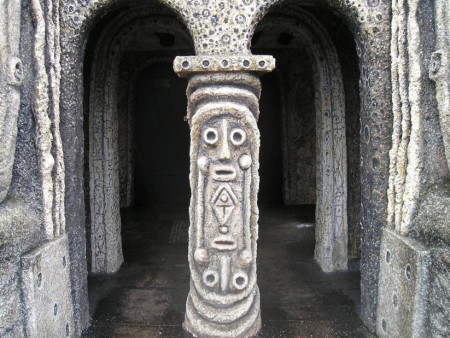
The emblem represents a sculpture (photo) part of the entrance gate of the Meditations' Garden designed by the artist by Robert Tatin (1902-1983) in his "House in the Fields" located in La Frénouse, a hamlet of Cossé-le-Vivien.
Robert Tatin started his professional life in Paris in 1918 as a painter and decorator and studied at the École des Beaux-Arts and at the École des Arts Appliqués. In 1930, he entered building trade, establishing in Laval a flourishing business that allowed him to travel to Europe, North Africa and New York.
In the aftermath of the Second World War, Tatin became a full-time artist; in 1947, he established in Paris a ceramics and painting workshop, where he met Jacques Prévert, André Breton, Alberto Giacometti, Jean Cocteau and Jean Dubuffet.
Tatin moved to Brazil in 1950, invited by Matarazzo Sobrinho, a rich industrialist, also director of the Fine Arts Museum in São Paulo; he traveled to Argentina, Paraguay, Uruguay and Chile, until Tierra del Fuego, where he met Amerindians and definitively dropped academic dogma.
Back to France in 1955, he became an internationally-renowned painter and was awarded the Critics Prize in 1961.
Robert Tatin and his wife, Lise, acquired in 1962 a small, traditional house in La Frénouse. Until their death in 1983 and 1986, respectively, Robert and Lise Tatin transformed the estate into their "House in the Field", organized around the Meditations' Garden. In 1967, Tatin erected a first concrete Giant along the 80 m-long alley heading to the house, now the Giants' Alley lined with 19 giants: Joan of Arc, Vercingétorix, The Verb "To Be", The Verb "To Have", St. Ann, The Virgin of l'Épine, The Master Companion, André Breton, Le Douanier Rousseau, Gauguin, Seurat, Auguste Rodin, Léonor Fini, Alfred Jarry, King Ubu, Toulouse-Lautrec, Valadon-Utrillo, Pablo Picasso, and Jules Verne. The Giant's Gate features statues portraying the painters Rembrandt, Van Gogh, Leonardo Da Vinci, Goya, and Delacroix.
Tatin's "art environment" was open to visit in 1967 as a municipal museum; officially inaugurated in 1969 by André Malraux, Minister of Culture, the Robert-Tatin Museum (website) is now managed by the Department of Mayenne.
- right: Saint-Aignan - Renazé.
The emblem represents a slate miner.
Slate has been exploited in Renazé since the late Middle Ages. In the 19th century, slate mines replaced the old quarries, which allowed industrialization of the production. The number of slate workers in the village increased from 400 in 1857 to 1,500 in 1920.
Production declined in the 1970e; the last shaft, butte Longchamp, was closed in 1975. In 1979, an association set up by former state workers and inhabitants of the village transformed the site in the Slate and Geology Museum (website, managed by the municipality of Renazé.
Olivier Touzeau & Ivan Sache, 27 April 2021
Les Coëvrons
![[Flag]](../images/f/fr-53-cv.gif)
Flag of Les Coëvrons - Image by Olivier Touzeau, 22 March 2021
The Communauté de communes des Coëvrons (29 municipalities; 27,350 inhabitants in 2017; 78,560 ha) was created in 2012 as the merger of the former Communauté de communes Pays d'Évron, Erve et Charnie, Pays de Montsûrs, and Bais.
The flag of Les Coëvrons (photo,
photo) is white with the authority's logo.
Olivier Touzeau, 22 March 2021
L'Ernée
![[Flag]](../images/f/fr-53-le.gif)
Flag of L'Ernée - Image by Olivier Touzeau, 23 April 2019
The Communauté de communes de l'Ernée (21,025 inhabitants in 2016; 47,915 ha) was created in 1994 as Communauté de communes du pays de l'Ernée, renamed Communauté de communes de l'Ernée in 2002. It is composed of the municipalities of Andouillé, Chailland, Ernée (seat), Juvigné, La Baconnière, La Bigottière, La
Croixille, La Pellerine, Larchamp, Montenay, Saint-Denis-de-Gastines,
Saint-Germain-le-Guillaume, Saint-Pierre-des-Landes and Vautorte.
The flag of L'Ernée, as seen at its seat, is white with the authority's logo, in the version with white and orange letters on blue.
Olivier Touzeau, 23 April 2019
Pays de Meslay-Grez
![[Flag]](../images/f/fr-53-pz.gif)
Flag of Pays de Meslay-Grez - Image by Olivier Touzeau, 14 April 2021
The Communauté de communes du Pays de Meslay-Grez (22 muncipalities; 14,033 inhabitants in 2016; 42,180 ha) was created in 2003 as the merger of the Communauté de communes de Meslay-du-Maine (which succeeded on 2001 the District de Meslay-sur-Maine, itself established in 1964) and of the Communauté de communes du Pays de Grez-en-Bouëre (est. in 1995).
The flag of Pays de Meslay-Grez (photo) is white with the authority's logo.
Olivier Touzeau, 14 April 2021
Pays d'Évron
![[Flag]](../images/f/fr-53-pv.gif)
Flag of Pays d'Évron - Image by Olivier Touzeau, 22 March 2021
The flag (photo) of the former Communauté de communes du Pays d'Évron (10 municipalities; 12,841 inhabitants in 2012; 20,743 ha) was white with the authority's logo.
Olivier Touzeau, 22 March 2021
Pays de Loiron
![[Flag]](../images/f/fr-53-pl.gif)
Flag of Pays de Loiron - Image by Olivier Touzeau, 20 December 2020
The flag (photo) of the former Communauté de communes du Pays de Loiron (14 municipalities; 17,038 inhabitants in 2016; 25,286 ha) was white with the authority's logo.
Olivier Touzeau, 20 December 2020