
Last modified: 2018-12-15 by rob raeside
Keywords: ukraine | transcarpathia | uzhgorod | uzhhorod | zakarpatska | uzgorod | hungary | beregovo | ruthenians | rusyn |
Links: FOTW homepage |
search |
disclaimer and copyright |
write us |
mirrors
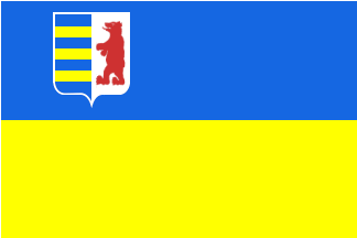
image by Viktor Lomantsov, 7 March 2009
See also:
Districts (Rayons):
Municipalities:
The new flag was adopted on 27 February 2009.
The chosen design was overwhelmingly selected by the deputies to
the local legislature ("Oblasna Rada" - Regional
Council)) in Uzhhorod.
Chrystian Kretowicz, 7 March 2009
You can see picture of
the flag on our
site.
Andriy Grechylo, 7 March 2009
Adittonal photo at <hhrf.org>.
The text refer to 29 February as adoption date.
Molnar Istvan, 9 March 2009
Capital: Uzhhorod (Soviet era name
in Russian: Uz^gorod). Transcarpathia/Zakarpatska area seized
from (Czecho)slovakia in 22 January 1946
Antonio Martins , 10 July 1999
The territory of present Transcarpathia (Zakarpats'ka oblast')
had not named before 1920. The territory was parts of the
following counties of Hungary: Bereg Co., Ung Co., Ugocsa Co. and
Ma'ramaros Co. Maybe it had got a name in Ruthenian (they are
indigenous people of the territory): Rusinsko??
Between 1918-1920 many countries claimed the territory.
Czechoslovakia, Rumania, Ukrainia, Hungary and of course the
Ruthens. The territory was united with Czechoslovakia and it was
an "historical territory" of Rusinsko. The Hungarian
name of the territory between the WW-s was Ruszinszko', later
Ka'rpa'talja. The Ruthenian name was Rusinsko or Pidkarpatska Rus
(Subcarpathia). In 1938 after the Decision of Munich the
territory got selfgoverment. In 1939, Hungary occupied the
territory, later annexed and made the autonomous territory:
Ka'rpa'talja - Pidkarpatska Rus. This territory had got own
symbols (I read about it, but I have never seen this symbols). In
1944 the Soviet Union occupied the territory and in 1945 the
annexed "Soviet of Transcarpathian Ucraine" "was
reunified" to the Soviet Union. In 1946 the Soviet Union
ceded the territory from Czechoslovakia and united it into
Ukraine. The name of the territory was Zakarpatskaya Oblast in
Russian, Zakarpatska oblast' in Ukrainian, Pidkarpatska Rus in
Ruthenian.
Istvan Molnar, 15 September 2000
From Ukrainian Heraldry
website :
In the X'th century the territory of Zakarpattia, populated by
the white Croatians, belonged to the Kyivs'ka Rus'. Only with the
beginning of the expansion of the Hungarians to the East the
territory began depend on them. Till XIII'th century the part of
Zakarpattia belonged to the Galyts'ko-Volyns'ke principality.
Since XVIth century the part of Zakarpattia became the part of
the Austria-Hungary, since 1919 – the part of Czechoslovakia.
In 1939 on the territory of Zakarpattia the creation of the
independent state – Karpats'ka Ukraine was declared. Since 1945
it is in the structure of Ukraine.
Zakarpats'ka oblast' (Trans-Carpathians region) was included in
Czechoslovakia under the name of Pidkarpats'ka Rus. It got its
CoA in 1920 for the first time.
Phil Nelson, 7 July 1999
Flags over Mukacheve, Uzhhorod and Berehove (before 1848:
approximately):
896-1000 Arpads' (Principality of Hungary) flag
1000-1301 Arpads' (Kingdom of Hungary) flags
1301-1305 Premysl's (Kingdom of Hungary) flag
1305-1307 Wittelsbach's (Kingdom of Hungary) flag
1307-1387 Anjou's (Kingdom of Hungary) flag
1387-1437 Luxembourg's (Kingdom of Hungary) flag
1437-1439 Habsburg's (Kingdom of Hungary) flag
1440-1444 Jagello's (Kingdom of Hungary) flag
1444-1453 Habsburg (Kingdom of Hungary, governor Hunyadi) flag
(in 1444 the first mention of the nowadays Hungarian CoA)
1453-1457 Habsburg (Kingdom of Hungary) flag
1458-1490 Hunyadi's (Kingdom of Hungary) flag
1490-1526 Jagello's (Kingdom of Hungary) flag
1526-1553 Szapolyai's (Kingdom of Hungary) flag
1527-1605 Habsburg (Kingdom of Hungary) flag
1605-1606 Bocskai's (Kingdom of Hungary) flag
1606-1620 Habsburg (Kingdom of Hungary) flag
1620-1621 Bethlen's (Kingdom of Hungary) flag
1621-1628 Bethlen's (Principality of Transylvania) flag
1628-1645 Habsburg (Kingdom of Hungary) flag
1645-1649 Rakoczi's (Principality of Transylvania) flag
1649-1682 Habsburg (Kingdom of Hungary) flag
1682-1683 Thokoly's (Principality of Upper-Hungary) flag
1683-1703 Habsburg (Kingdom of Hungary) flag
1703-1711 Rakoczi's (Kingdom of Hungary) flag
1711-1848 Habsburg and Hungarian (Kingdom of Hungary) flags
1848-1849 Hungarian (Kingdom of Hungary) flag
1849-1867 Austrian (Empire of Austria) flag (black-yellow)
1867-1918 Hungarian (Kingdom of Hungary) flag
1918-1919 Hungarian (People's Republic of Hungary) flag (with
Kossuth CoA or without CoA)
1919 Red (Hungarian Soviet Republic) flag
1919 Romanian flag (occupation)
1919-1938 Czechoslovakian (Republic of Czechoslovakia) flag
1938-1944 Hungarian (Kingdom of Hungary) flag
1944-1946 Soviet flag (occupied territory, maybe Czechoslovakian
flag?)
1946-1992 Soviet and Soviet-Ukrainian flags (1946-1952-1992)
1992-now Ukrainian (Republic of Ukraine) flag
Istvan Molnar, 27 November 2000
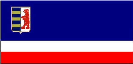
image from <rusinpresent.narod.ru>
On <rusinpresent.narod.ru>,
there is an actual project of flag of the Transcarpathian Region
(Zakarpatskaya Oblast) of Ukraine.
Flag is blue, white and red (2:1:1) with Coat of Arms.
Mikhail Revnivtsev, 6 March 2007
zk.gif)
image from Ukrainian Heraldry
website
From Ukrainian Heraldry
website :
Here is the description of that Coat of Arms in the middle-sized
and in the big Coat of Arms of Czechoslovakian Republic according
to the Law No.252 of March 30 1920: "On the back state
shield in the top left field there is an Coat of Arms of
Pidkarpats'ka Rus. That shield is cut into two halves - in the
right azure field there are three or stripes, in the left argent
field there is a red bear standing on its hind legs and looking
to the right."
In March 1939 there was formed an independent state - Karpats'ka
Ukraine. That state in its first law of March 15 decided:
"The national Coat of Arms of Karpats'ka Ukraine is the
present Coat of Arms of the region: a red bear in the left red
field and four azure and three or stripes in the right field and
a trident of St.Volodymyr the Great with a cross on the middle
prong."
On the 18th of December 1990 the Principle about the Coat of Arms
of Zakarpats'ka oblast' was adopted: "The Coat of Arms of
Zakarpats'ka region has a form of a cut shield. In the right part
there are seven equal horizontal stripes with interchange of
azure and or (the first stripe is azure); in the left part of an
argent field there is a picture of a red bear standing on its
hind legs and looking to the left."
Phil Nelson, 7 July 1999
The Coat of Arms of Transcarpathian Region were adopted by
Regional Council on December, 18, 1990. The description of the
CoA: Per pale, 1) barry of seven Azure and Or; 2) Argent, a Bear
Gules. The Coat of Arms is analogous to adopted official Regional
Coat of Arms of 1920 and to Coat of Arms of Authonomous
Carpathian Ukraine of 1938 and semi-analogous to Coat of Arms of
independent Carpathian Ukraine of 1939 (Coat of Arms of 1939 had
a gold trident in the canton).
Victor Lomantsov, 28 July 2000
I have bought a map: Karpatalja - Zakarpat'ska oblast'. Some
information from this map:
The territory of Transcarpathia is divided to 13 distrits and 3
cities. In Transcarpathia there are 7 towns, 20 places of town
type, 297 villages with own community and 282 villages withou
community. The territory of Transcarpathia is 12.880 km2.
Transcarpathia has got 1.287.400 inhabitants (1999 datas).
The list of the districts and towns
Districts:
Berehivs'kyj rayon (83.700 inh.)
Velykij Bereznjans'kyj rayon (30.000)
Vynohradivs'kyj rayon (118.400)
Volovec'kyj rayon (27.200)
Irshavs'kyj rayon (99.000)
Mizhhirs'kyj rayon (50.700)
Mukachivs'kyj rayon (104.300)
Perechyns'kyj rayon (32.700)
Rachivs'kyj rayon (91.300)
Svaljavs'kyj rayon (57.600)
Tjachivs'kyj rayon (172.700)
Uzhhorods'kyj rayon (73.800)
Husts'kyj rayon (94.800)
Cities:
Berehovo (29.200) (from 17 May 2001)
Uzhhorod (126.600)
Mukachevo (89.100)
Hust (35.500)
Towns and places of town type:
Solotvyno ptt (TJ; 9.900 inh.)
Bat'ovo ptt (BE; 3.000)
Bushtyno ptt (TJ; 8.300)
Chop town (UZ; 9.700)
Dubove ptt (TJ; 10.400)
Kobylec'ka Poljana ptt (RA; 3.300)
Irshava town (IR; 10.600)
Koroljevo ptt (VY; 7.900)
Ust'-Chorna ptt (TJ; 1.500)
Kol'chyno ptt (MU, 4.800)
Jasinja ptt (RA; 1.500)
Velykyj Bereznyj ptt (VB; 7.300)
Velykyj Bychkiv ptt (RA; 9.400)
Vynohradiv town (VY; 27.600)
Mizhhir'ja ptt (MY; 10.200)
Perechyn ptt (PE; 7.500)
Rachiv town (RA; 17.000)
Zhdenievo ptt (VO; 1.400)
Chinadijovo ptt (MU; 7.300)
Seredne ptt (UZ; 3.500)
Svaljava town (SV; 18.800)
Teresva ptt (TJ; 7.600)
Tjachiv town (TJ; 11.300)
Vylok ptt (VY, 3.700)
Vyshkovo ptt (HU; 8.100)
Volovec' ptt (VO; 5.800)
Datas from the "Karpatalja terkepe" 1:250 000; DIMAP
Bt., Budapest 2000
Istvan Molnar, 26 November 2000
hung.gif)
image by Chris Kretowicz, 2 June 2001
In Transcarpathia live about 200.000 Hungarians, most of them
in the frontier zone. They use the Hungarian national flag with
or without the Hungarian Coat of Arms. You can see many Hungarian
flags in the churches, offices and on the City Hall of Beregovo /
Beregszasz. The settlements officially use the Ukrainian state
flag, their own flags and the Hungarian National flag. The
organizations and parties - has own Coat of Arms or symbol. I
haven't seen party flag yet. On the days of the Hungarian
National Holidays you can see many red-white-green flags in the
Hungarian-lived territories.
Istvan Molnar, 15 September 2000
Karpataljai Magyar Kulturalis Szovetseg - Cultural Association
Of Hungarians In Subcarpathian (CAOHIS) - The largest political
and cultural organization of Hungarians in Ukraine. Home page
<www.karpatok.uzhgorod.ua>.
Istvan Molnar, 9 June 2001