
Last modified: 2021-03-13 by rob raeside
Keywords: guyana | upper takutu-essequibo | rupununi |
Links: FOTW homepage |
search |
disclaimer and copyright |
write us |
mirrors
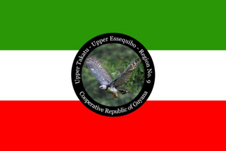 image located by Jason Saber, 7 June 2019
See also:
From "Emblems, Flags and Colours of the Regions of the Cooperative Republic
of Guyana", apparently published by the Government of Guyana.
Upper Takutu-Essequibo - Region No. 9
The Kanuku and Kamoa highlands and the
vast Rupununi savannahs make up the Upper Takutu-Upper Essequibo region. The
forested Kanuku Mountains divide this Region in two. The north savannahs are
about 2,000 square miles in area, and the south savannahs are 2,500 square
miles. The population of 15,087 lives in scattered Amerindian villages and land
settlement schemes.
Because of the grassy savannahs, the Rupununi is
considered to be 'cattle country'. Most of the cattle are farmed to produce
beef, and a few are kept for milk. There are large ranches at Aishalton, Annai,
Dadanawa and Karanambo. Much of the beef produced here is sold in neighbouring
Brazil, because transportation to the other regions of Guyana, especially Region
Four, is very expensive.
The people of this region also mine semiprecious
stones among the foothills of the Kamoa Mountains and among the Marundi
Mountains. A wide variety of craft is produced in many of the seventeen
Amerindian villages, and sold mainly to Brazil.
In Region Nine, you can
see the Giant River Otter, the Arapaima (the largest freshwater fish in the
world) and the black Cayman.
Jason Saber, 7 June 2019
The symbol is proposed to be the national bird, the Harpy Eagle in flight and
the colours; green for forest wealth, red for zeal of the people and white for
the water resources.
Jason Saber, 7 June 2019
 image located by Jens Pattke, 9 June 2019
Source:
https://demerarawaves.com
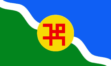 image by Olivier Touzeau, 1 February 2021
The Rupununi Uprising was a secessionist insurrection in Guyana in January
1969. It was recognized as the largest threat to Guyana's national security when
Venezuela disputed territorial control of the Guayana Essequiba, amounting to
two-thirds of Guyana's territory.
(summing up from Wikipedia):
Five
months after Guyana's independence from the United Kingdom, Venezuelan troops
began their occupation of Ankoko Island in October 1966. Subsequently, Forbes
Burnham, as Prime Minister and Minister of External Affairs of Guyana,
dispatched a protest to the Foreign Minister of Venezuela, demanding the
withdrawal of Venezuelan troops. Venezuelan minister Ignacio Iribarren Borges
replied stating "the Government of Venezuela rejects the aforementioned protest,
because Anacoco Island is Venezuelan territory in its entirety and the Republic
of Venezuela has always been in possession of it".
At the time, Venezuela
used diplomatic, economic and military pressure against Guyana in order to
acquire the Essequibo territory. Venezuelan actions to acquire Guyanese
territory intensified in 1968, with militarization occurring on the
Guyana-Venezuela border at the time. President Leoni declared an annexation of 9
miles of coastline in the Essequibo on 9 July 1968, stating that the Venezuelan
Navy would enforce the area.
Following the 1968 Guyanese general election,
Valerie Hart declared herself president of the "Republic of the Rupununi",
claiming control of the Rupununi region of Guyana. The rebels were primarily
ranch owners of European descent that were supported by Amerindians, who were
mainly ranch employees. Venezuela supported and sponsored the Rupununi rebels
and their secession movement. In an effort to receive support from Venezuela,
Hart and her rebels stated that they would grant Venezuela control of Guyana's
disputed Guayana Esequiba territory in exchange for assistance.
On 2 January
1969, rebels flew in a Douglas C-47 Skytrain operated by Venezuelan personnel to
Pirara, Guyana, north of Lethem. Valerie Hart, the rebel leader, flew to Caracas
aboard the Douglas C-47 Skytrain's returning flight. Rebels began their attacks
on Lethem in the morning, killing five police officers and two civilians while
also destroying buildings belonging to the Guyanese government with bazooka
fire. The rebels locked citizens in their homes and blocked airfields in Lethem,
Annai Good Hope, Karanambo and Karasabai, attempting to block staging areas for
Guyanese troops.
As the Guyana Defence Force approached Lethem, the rebels
quickly fled and the uprising ended. About thirty of the rebels were arrested
following the uprising. Members of the failed uprising fled to Venezuela for
protection, with Hart and her rebels being granted Venezuelan citizenship by
birth since, according to the Venezuelan government, they were recognized as
being born in what Venezuela described as "the Reclamation Zone".
When it was
apparent that the uprising movement had failed, the Venezuelan government
refused to further assist with the uprising and all support ended with the
inauguration of Rafael Caldera on 11 March 1969. After the uprising, Venezuela
President Rafael Caldera and Burnham were concerned with the reclamation of
Guayana Esequiba. Their concern led to the Port of Spain Protocol in 1970.
Olivier Touzeau, 1 February 2021
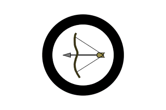 image by Olivier Touzeau, 1 February 2021
According to this blog (maintained by supporters of Venezuelan sovereignty on
the Essequibo region) :
http://esequibonuestro.blogspot.com/2012/02/simbolos-de-soberania.html
here is some information about the possible flag of the Rupununi.
"Its origin
comes from the symbol of the Guyanese Amerindian Party (Guyana Amerindian
Party), who in 1966 [....] rebelled on January 2, 1969 by taking the Lethem
airport and declaring its annexation to Venezuela. [...] The white flag has a
bow and arrow symbolizing the Amerindian race and the commitment to defend their
land and customs."
Olivier Touzeau, 1 February 2021