
Last modified: 2020-04-12 by rob raeside
Keywords: guyana | mahaica-berbice |
Links: FOTW homepage |
search |
disclaimer and copyright |
write us |
mirrors
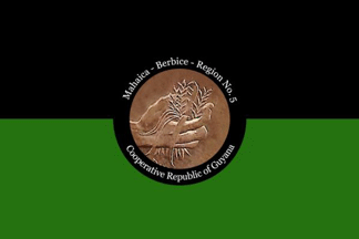 image located by Jason Saber, 7 June 2019
See also:
From "Emblems, Flags and Colours of the Regions of the Cooperative Republic
of Guyana", apparently published by the Government of Guyana.
Mahaica-Berbice - Region No. 5
The Mahaica-Berbice Region extends east of the
Mahaica River to the west bank of the Berbice River. A large part of the region
is low coastal plain. Further inland lays the Intermediate Savannahs and hilly
sand and clay region.
The population of Region Five: 49,498, is much lower
than in Region Four. Rice farming is the main economic activity of this region,
followed by sugar and coconut farming, and beef and dairy cattle ranching. The
Region has a water conservancy project aimed at improving the drainage and
irrigation of the area. Great dams were erected across the headwaters of the
Mahaica, Mahaicony and Abary Creeks to prevent the flooding of the farmlands in
front of them during the wet seasons. During the dry seasons, the dams are
opened to allow the land to be properly irrigated.
Amerindians living in
inland settlements make beautiful nibbi furniture, tibisiri baskets and other
craft items, which they sell to earn their living.
Jason Saber, 7 June 2019
The colours for this flag will be green to represent their strong
agricultural economic value and black to represent the strength of the people.
The symbol is an image of a rice farmer planting rice.
Jason Saber, 7 June 2019
 image located by Jens Pattke, 9 June 2019
Source:
https://demerarawaves.com