
Last modified: 2021-08-26 by  klaus-michael schneider
Keywords: boyaca | samaca |
Links: FOTW homepage |
search |
disclaimer and copyright |
write us |
mirrors
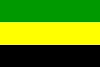
image by Jorge Candeias, 11 April 2004
See also:
The municipality of Samacá (19,907 inhabitants in 2015, 5,908 in the urban
area; 17,290 ha) is located in the center of the Boyacá Department, 30 km of
Tunja and 160 km of Bogotá.
Samacá is a name of Chibcha origin; the village is mentioned in the early
colonial surveys as Camaca. On 20 August 1537, Gonzalo Jiménez de Quesada
overthrew Zaque (Prince) Quimuinchatecha, who converted to the Christian
religion and retired from public life. Several of his vassals revolted against
the colonists; in 1540, the caciques (local rulers) of Boyacá, Motavita, Samacá,
Suta, Toca and Turmequé were captured and publicly beheaded in Tunja.
The official date of foundation of Samacá is 1 January 1556, the date of a synod
during which Friar Juan de los Barrios, Archbishop of Bogotá, commissioned
Father Tomás Grijalva to evangelize the Indians of Samacá.
The first alcalde (Mayor) of Samacá was appointed on 24 December 1756, while the
parish of the municipality of Samacá was erected on 7 October 1776.
Ivan Sache, 02 September 2017
From <samaca-boyaca.gov.co>:
"Amarillo representa la riqueza
Verde representa el verdor de sus campos.
Negro fuentes carboniferas."
Jairo Alonso Méndez Méndez, 28 October 2006
The explanation of the colors of the flag reads as:
Yellow represents wealth.
Green represents the greenness of the fields.
Black represents the resources in coal.
The design of the flag is credited to César Eduardo Martinez Cuevas.
Ivan Sache, 02 September 2017
boysm.jpg)
image from <samaca-boyaca.gov.co>