
Last modified: 2013-04-27 by ian macdonald
Keywords: sao paulo | itararé |
Links: FOTW homepage |
search |
disclaimer and copyright |
write us |
mirrors
 image by Ivan Sache, 15 April 2013
Itararé was established between Rivers Verdé and Itararé, in an area
first mentioned in 1776 as Campos de São Pedro (St. Peter's Fields).
The São Pedro estate was delimited in 1855. Colonel Licínio Carneiro
de Camargo offered in 1879 a piece of land to erect a chapel near the
pre-existing settlement of Itararé. The chapel, dedicated to Our Lady
of the Conception of Itararé, was consecrated in 1881.
The municipality of San Pedro de Itararé was established by Law No.
197 of 28 August 1893, seceding form the municipality of Faxina
(today, Itapeva).
http://www.itarare.com.br/consideracoes.htm - Unofficial website
The symbols of Itararé are prescribed in Article 11 of the Municipal
Constitution, adopted on 27 August 1990, as "the flag, the coat of
arms and the anthem established by Municipal Law".
http://www.itarare.sp.gov.br/pmdi/images/stories/docs/lomi.doc -
Municipal Constitution
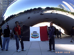
The flag is vertically divided black-white-red with the municipal coat of arms in the middle.
Photos
http://camaramunicipalitarare.com.br/noticiasExibe.php?id=133
http://3.bp.blogspot.com/-U5_9BY73dnE/Tn5QOhzwUsI/AAAAAAAAAY8/AaoEVBrG_Ck/s240/itararechicago.jpg
http://www.virtualguia.com.br/n/prefeito-visita-delegacao-de-itarare-que-participa-do-16-jori-em-tatui
http://camaramunicipalitarare.com.br/noticias_geral.php?id=70