
Last modified: 2013-06-01 by ian macdonald
Keywords: sao paulo | itaporanga |
Links: FOTW homepage |
search |
disclaimer and copyright |
write us |
mirrors
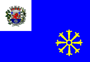 image by Ivan Sache, 14 April 2013
Itaporanga was founded in 1845 by Friar Pacífico de Monte Falco, one
of the Italian Capuchine monks commissioned in 1843 by José da Silva
Machado, Baron of Antonina, to evangelize the natives living on his
domain. The village was originally named São João Batista do Rio
Verde. The parish of São João Batista was established by Provincial
Law No. 1 of 5 March 1855, as part of the municipality of Faxina
(today, Itapeva).
The municipality of São João Batista do Rio Verde was established by
Provincial Law No. 7 of 6 March 1871, inaugurated on 22 January 1873
and renamed Itaporanga by State Law No. 620 of 21 June 1899.
Itaporanga means "beautiful stone" in Tupi-Guarani, referring here to
the numerous stones found along Rio Verde.
http://itaporanga.sp.gov.br - Municipal website
The flag of Itaporanga is blue with a white square canton charged with the municipal coat of arms. In lower fly is placed a yellow circular emblem with eight points flory, also represented in the base of the shield.
Photos
http://itaporanga.sp.gov.br/novoportal/not%C3%ADcias/246-escola-%E2%80%9Cpe-osvaldo%E2%80%9D-comemorou-anivers%C3%A1rio-de-itaporanga.html
http://www.itaponews.com.br/v1/images/stories/5dc693ffbef6_967/Torneio-Intermunicipal-de-Volei-de-Itaporanga-SP.jpg
Ivan Sache, 14 April 2013