
Last modified: 2012-12-15 by ian macdonald
Keywords: sao paulo | igaratá |
Links: FOTW homepage |
search |
disclaimer and copyright |
write us |
mirrors
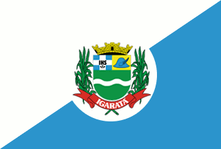 image by Dirk Schönberger,
9 November 2012
image by Dirk Schönberger,
9 November 2012
Source:
http://pt.wikipedia.org/wiki/Igarat%E1
Divided per bend sinister white over blue with the municipal arms on a white disk in the centre.
Official website at
http://www.igarata.sp.gov.br
Dirk Schönberger,
9 November 2012
Igaratá originates in the establishment at the end of the 18th century of the settlement of Patrocínio de Santa Isabel. The settlements emerged near a chapel dedicated to Our Lady of the Patronage ("patrocinio"), built on the bank of river Jaguari - a tributary of Paraíba - on the territory of Santa Isabel. The region was colonized by emigrants who had left Minas Gerais after the exhaustion of gold resources and introduced coffee cultivation in the Paraíba Valley. The parish of Patrocínio de Santa Isabel was established on 19 April 1864 by Provincial Law No. 24, as part of the municipality of São José do Paraíba. The parish was transferred to the municipality of Santa Isabel on 9 May 1868 by Provincial Law No. 64. The municipality of Patrocínio de Santa Isabel, aka Nossa Senhora do Patrocínio de Santa Isabel, was established on 23 April 1873 by Provincial Law No. 80. The name of the municipality was changed to Igaratá on 22 December 1906 by State Law No. 1,042. Igaratá comes from Tupi-Guarani "ygara- atã", "a big canoe" / "a strong canoe". Following the decline of coffee, the population decreased and the municipality was suppressed on 21 May 1934 by State Decree No. 6,448, which established the district of Igaratá, part of the municipality of Santa Isabel. The municipality of Igaratá was re-established on 3 December 1953 by State Law No. 2,456 and inaugurated on 1 January 1955. In 1968, the building of the Jaguari Dam, part of the State Hydroelectric System managed by CESP (Centrais Elétricas de São Paulo), required the flooding of the old town of Igaratá. A brand new urban nucleus, locally known as Nova Igaratá, was inaugurated on 5 December 1969, being located 3 km from the old, disappeared nucleus.
The flag is divided white-celeste blue by the ascending diagonal. In the middle of the flag is placed a white disk charged with the municipal coat of arms.
Photos of the flag
http://niltoncesarigarata.blogspot.fr/2012/08/vereador-consegue-beneficio-aos.html
http://www.jbomdia.com.br/portal/?pg=noticia&id=578
Ivan Sache, 10 November 2012