
Last modified: 2013-04-27 by ian macdonald
Keywords: sao paulo | igarapava |
Links: FOTW homepage |
search |
disclaimer and copyright |
write us |
mirrors
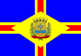 image by Ivan Sache, 10 April 2013
Image
contributed on 16 October 2012 to Wikimedia Commons by "ViniciusBR11"
Igarapava was founded on 22 May 1842 on the territory of the Varzem Alegre Estate, owned by Captain Anselmo Ferreira de Barcelos. Together with Father Zeferino Baptista do Carmo, he erected a chapel dedricated to Santa Rita do Paraíso. The village that developed nearby took the same name. The district of Santa Rita do Paraíso was established by Provincial Law No. 7 of 7 February 1851, as part of the municipality of Franca. The municipality of Santa Rita do Paraíso was established by Provincial Law No. 51 of 14 April 1873, inaugurated on 20 February 1874, and renamed Igarapava by State Law No. 1,097 of 4 November 1907. In Tupi-Guarani, "igara" means "a small canoe made from the trunk of a single tree", while "pava" means "a port". This refers to Porto de Ponte Alta, aka Porto das Canoas, where several canoes were used to cross Rio Grande.
The symbols of Igarapava are prescribed in Article 2 of the Municipal
Constitution, adopted on 5 April 1990, as "the flag, the anthem and
the coat of arms, representative of its culture and history".
http://camaraigarapava.sp.gov.br/leiorga.html - Municipal Constitution
The flag is blue with a yellow-red-yellow saltire. In the middle of the flag is placed a yellow lozenge charged with the municipal coat of arms.
The cross represents the Christian faith of the people. The coat of arms represents the municipal government, while the lozenge that inscribes it represents the town as the seat of the municipality. Yellow is a symbol of glory, splendour, wealth, greatness and sovereignty. The stripes represent the municipal power spreading all over the municipal territory. Red is a symbol of dedication, patriotic love, audacity, intrepidity, courage and valiance. The quarters represent the rural estates located on the municipal territory. Blue is a symbol of justice, nobleness, perseverance, zeal, loyalty, recreation and beauty.
The coat of arms is prescribed by Municipal Law No. 230 of 23 April 1957 as follows: "A Portuguese shield or with a simple compass rose sable and argent inscribed with the year '1842' sable - the year of foundation of the town - over a fess wavy azure an expedition's canoe with two rows all or. The shield surmounted by a mural crown or. The shield supported by two sugarcanes. Beneath the shield a scroll gules inscribed with the municipality's name in letters sable."
The Portuguese shield recalls the origin of the town, formed within
the Captaincy of São Paulo.
The compass rose and the four cardinal points symbolize the route
followed by the pioneers to develop the hinterland.
The canoe makes the arms canting, the name of the town being formed on
the Tupi-Guarani words "igara", "a canoe", and "pava", " a port".
Sugarcane is the main crop in the municipality.
http://camaraigarapava.sp.gov.br/cohistiga.html - Website of the
Municipal Council
Photo of the flag
http://www.camaraigarapava.sp.gov.br/noticias3/noticia151.html
http://camaraigarapava.sp.gov.br/noticias/noticia24.html
http://heliorodriguesribeiro.zip.net/arch2009-01-11_2009-01-17.html
http://camaraigarapava.sp.gov.br/noticias/noticia11.html
http://camaraigarapava.sp.gov.br/NOTICIAS2/noticia105.html
http://t1.gstatic.com/images?q=tbn:ANd9GcRF6xYtL1WRKftiUFhg-1XK5U61BtxymK98GmdJ0ZiGsw7lwhnqzw