
Last modified: 2020-07-12 by ian macdonald
Keywords: rio grande do sul | arroio do meio |
Links: FOTW homepage |
search |
disclaimer and copyright |
write us |
mirrors
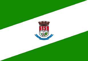 image by Ivan Sache,
11 July 2020
image by Ivan Sache,
11 July 2020
The municipality of Arroio de Meio (20,272 inhabitants in 2017; 15,796 ha) is
located 130 km of Porto Alegre.
Arroio de Meio was established in 1816 by
Ricardo Josť Villanova, from Taquari, who was granted the domain of S„o Caetano.
In 1844, he sold S„o Caetano to another inhabitant of Taquari, Captain Francisco
Silvestre Ribeiro. The S„o Caetano fazenda was initiated in 1850 with the
building of huts for workers and slaves and of a sugar mill. After the captain's
death, his sons sold the domain. In 1860, Johann Gerhard and his sons purchased
a part of it, being the first German colonists to settle in Arroio de Meio. In
1861, another part of the domain, including the today's downtown, was acquired
by AntŰnio Fialho de Vargas.
In the 1860-1870, more German and Italian
colonists came to Arroio de Meio. At the time, the settlement, depending on
Taquiri, was known as Nossa Senhora do AuxŪlio da Barra do Arroio do Meio. It
was subsequently incorporated to Estrela, then to Lajeado.
The municipality
of Arroio de Meio was established by State Decree No. 5,759 issued on 28
November 1934, and inaugurated on 2 January 1935.
http://www.arroiodomeio.rs.gov.br
- Municipal website
Ivan Sache, 11 July 2020
The flag of Arroio de Meio was designed by Sisters Eda and
Amťlia, from Colťgio S„o Miguel. Its main color is green, with a white diagonal
stripe charged in the center with the municipal coat of arms.
The coat of
arms of Arroio de Meio was defined on 3 October 1968.
It is composed of a
Portuguese shield divided into two parts. The first part is a field separated by
three lines representing the three streams tributaries of river Taquari: Arroio
Forqueta [Forked Stream], Arroio do Meio [Middle Stream], and Arroio Grande [Big
Stream]. On the central line is placed a star, symbolizing the name of the
municipality (on Arroio do Meio). Beneath, placed horizontally, river Taquari
and the three streams flowing in. In the lower part of the shield a maize cob
and a branch of soybean, representing the main crops in the municipality. On the
scroll placed beneath the shield the municipality's name surrounded by years
"1853" - foundation of the Arroio do Meio colony - and "1934" - municipal
emancipation. The shield surmounted by a mural crown with four castles,
representing the four powers : Executive Legislative, Judiciary, and
Ecclesiastic.
http://www.arroiodomeio.rs.gov.br/site/sobre - Municipal website
Ivan Sache, 11 July 2020