
Last modified: 2020-04-18 by rob raeside
Keywords: panama | coclé | aguadulce |
Links: FOTW homepage |
search |
disclaimer and copyright |
write us |
mirrors
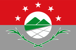 image by Olivier Touzeau,
20 January 2017
image by Olivier Touzeau,
20 January 2017See also:
The district of Aguadulce (19,037 inhabitants in 2010; 5,040 ha) is located
on the Pacific coast of Panamá, 50 km south of Penonomé and 200 km south west of
Panamá City.
Ivan Sache, 3
June 2019
According to
http://www.panamaamerica.com.pa/provincias/aguadulce-ya-tiene-su-bandera-1045518
and
http://www.prensa.com/provincias/Nueva-Aguadulce-presentada-aniversario-distrito_0_4591040855.html
the district of Aguadulce in Coclé Province, Panama, has adopted a flag: a
municipal decree from 13th September 2016 adopted the flag and it was published
in the official gazette on the 3rd of October. The flag was displayed for the
first time on 19th October 2016 for the anniversary of the foundation of the
district in 1848.
It consists of two rectangular stripes of equal size,
with red upper stripe in honor of San Juan Bautista, patron of Aguadulce, and
gray lower stripe representing the district's progress. The five white stars
represent each of the corregimientos (Aguadulce, Pocri, Barrios Unidos, El
Cristo, Roble). On the central white disk are two hills, one of which is the
Vigia hill, which was an important place during the Thousand Days' War
(1899-1902). The green part under the hills stands for the mangroves, and the
white squares for salt works.
Under the disk are two sugar canes.
The
flag was designed by John Michael Varela Varela, and was chosen through a
contest organized by the Municipal Council of Aguadulce.
Olivier Touzeau,
20 January 2017
The flag of Aguadulce is prescribed by Agreement No. 71, adopted on 13
September 2016 by the Municipal Council and published on 3 October 2016 in the
Panamá official gazette, No. 28,130.
Article 2.
The flag of the
District of Aguadulce is composed of two rectangular stripes of equal size, with
the color red and gray, in descending order, described as follows:
The red
color in the upper part honors St. John the Baptist, the patron saint of the
District of Aguadulce. The gray color in the lower part represents progress and
the past and future works that make of Aguadulce a powerful and progressing
district. The five white stars represent peace and the union of the five
corregimientos of Aguadulce Capital, Pocrí, El Cristo, El Roble, and Barrios
Unidos.
In the flag’s center is a white circle featuring two heights
representing Cerro Vigía (Watch Hill); one of them was used to watch vessels
heading to the coast in the times of Victoriano Lorenzo [1867-1903, a hero of
the Panamanian independence), while the other was sued to watch troops heading
from land to Natá in the battle fought between the Liberal and the Conservators
during the Thousand Days’ War [1899-1902]. Beneath the hills, a green stripe
represents mangrove, an habit for marine species and mollusks that fed natives
and foreigners.
The white squares represent salterns, whose product has been
since the prehistoric times a source of labor and of a great commercial
activity, being used by travelers to preserve meat during sea voyages.
Beneath the circle, are two crossed sugarcanes, the plant used to obtain the
product [sugar] connected to the district’s commerce and development; together
with salt, it yielded to Aguadulce the nickname of "Land of Salt and
Sugar".
https://www.gacetaoficial.gob.pa/pdfTemp/28130/58155.pdf
The flag
was inaugurated on 19 October 2016.
Photos
https://www.diaadia.com.pa/el-pa%C3%ADs/hijos-meritorios-y-bandera-nueva-en-aguadulce-302398
https://www.panamaamerica.com.pa/provincias/desfile-civico-en-aguadulce-en-homenaje-fundacion-del-distrito-1047743
https://www.midiario.com/uhora/nacionales/aguadulce-luce-su-nueva-bandera/
https://twitter.com/contraloriapma/status/789833640012242944
Ivan Sache, 3
June 2019
01.gif) image by Fred Drews, 2 November 2018
image by Fred Drews, 2 November 2018