
Last modified: 2018-12-15 by rob raeside
Keywords: helden |
Links: FOTW homepage |
search |
disclaimer and copyright |
write us |
mirrors
 Shipmate Flagchart : http://www.flagchart.net
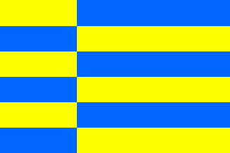
adopted 8 Sep 1969
According to the official site at the Helden
municipal site:
The flag was adopted by approval of the municipal council on 8 September
1969. The flag shows a division of 6 equal stripes over the width of the
flag, alternatively yellow and blue on the hoist end, and blue and yellow
on the fly, in such way that 6 large and 6 small stripes are created. These
larger stripes stand for the 6 main villages and the smaller stripes for
the 6 communes, that together formed the original municipality of Helden.
Because of the alternating colours in the flag a vertical line is created,
this line represents the language (or dialect) border that crosses our
municipality. North of the line Weert-Venlo a Brabants-Gelders dialect
is spoken, and south of this line the real Limburgs dialect is spoken.
The 6 villages are: Beringe, Egchel, Grashoek, Helden, Koningslust
and Panningen. The 6 communes are Zelen, Onder, Dreese, Everlo, Hub and
Loo. (according to their friendly response on my e-mail)
Franc van Diest, 3 Nov 2000
![[Helden Coat of Arms]](../images/n/nl-li)hd.jpg) image from the Helden municipal site.
image from the Helden municipal site.
Granted 28 Sep 1867; the saint is St. Lambertus, patron saint of the municipality.