
Last modified: 2020-04-12 by rob raeside
Keywords: guyana | essequibo islands-west demerara |
Links: FOTW homepage |
search |
disclaimer and copyright |
write us |
mirrors
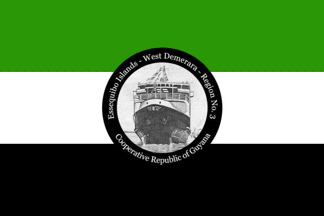 image located by Jason Saber, 7 June 2019
See also:
From "Emblems, Flags and Colours of the Regions of the Cooperative Republic
of Guyana", apparently published by the Government of Guyana.
Essequibo Islands-West Demerara - Region No. 3
The Essequibo Islands-West
Demerara Region is made up of the islands in the Essequibo River such as Leguan
and Wakenaam, and the Western portion of mainland Demerara. It is made up of low
coastland, hilly sand and clay, and a small portion of forested highland
regions. This Region has a population of 91,328 people who live in villages,
many along the coast. Rice farming is predominant, with small amounts of sugar
and coconut cultivation.
The Boerasirie Extension Project converted the
Boerasire Conservancy and the Canals Polder Conservancy into a single reservoir,
and reclaimed thousands of hectares of land, suitable for farming. The water
from the conservancy is used during the dry seasons for irrigation. Sugar cane
and coconuts are cultivated on a smaller scale and there is also beef and dairy
farming.
Jason Saber, 7 June 2019
The colours for this flag are green to represent the rich agricultural value,
black to represent the endurance of the people, and white to depict the water
resources. The Symbol is the M.V. Torani.
Jason Saber, 7 June 2019
 image located by Jens Pattke, 9 June 2019
Source:
https://demerarawaves.com