
Last modified: 2021-08-25 by rob raeside
Keywords: belize | hurrican | signal flags |
Links: FOTW homepage |
search |
disclaimer and copyright |
write us |
mirrors
See also:
Belize, all too often suffering from hurricanes, has a
four-flag warning system shown on this page, which is part of a
brochure:
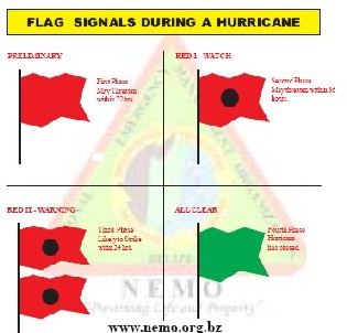
"Flags signals during a hurricane
Preliminary. First phase. May threaten within
72 hrs. [red flag]
Red 1 – Watch. Second phase. May threaten
within 36 hrs. [red flag with black dot in centre]
Red II – Warning. Third phase. Likely to
strike within 24 hrs. [two red flags with black disks above each
other]
All Clear. Fourth Phase. Hurricane has passed.
[green flag]
Belize’s NEMO (National Emergency Management Organization)
Mission Statement from its website:
“NEMO in cooperation with the respective Emergency
Management Committees, and all Public and Private agencies, is
established to preserve life and property throughout the country
of Belize in the event of an emergency, threatened or real, and
to mitigate the impact on the country and its people.”
The following
page shows the flags in question (NEMO Secretariat Open Day,
Belmopan, 1 June 2006): Photo four of the series (partially) and
especially photo eleven.
Clearly inspired by the US system,
the Belize hurricane flags nevertheless have a touch of their
own.
Jan Mertens, 26 February 2007
According to this WMO
page, Belize uses following flags shown on a table:
- 43a (plain red):
(i) "A tropical depression moves into or develops anywhere
in the quadrant south of 211°N latitude and west of 80°W
longitude, OR
(ii) A tropical storm or hurricane moves into or develops
anywhere in the quadrant south of 21°N latitude and between
longitudes 80°W and 83°W".
- 45a (green): "The tropical depression, tropical storm or
hurricane has passed or not longer poses a threat to Belize and
coastal waters.
- 41a (double set of red pierced black): " A tropical storm
or hurricane moves into or develops anywhere in the quadrant
south of 20° N latitude and west of 85°W longitude."
- 40a (red pierced black): "A tropical [storm] or hurricane
moves into or develops anywhere in the quadrant south of 20°N
latitude and between longitudes 83°W and 85°W."
However as shown above, this information needs to be qualified
and especifically since the black rectangle is replaced, in
Belize at least, by a black dot (see links to photos).
Jan Mertens, 4 November 2007

image by António Martins-Tuválkin, 10 August 2007

image by António Martins-Tuválkin, 10 August 2007
images by António Martins-Tuválkin, 10 August 2007

image by António Martins-Tuválkin, 10 August 2007