Last modified: 2026-10-17 by martin karner
Keywords: emek hefer | regional council | mo'atza ezorit emek hefer | text: hebrew (green) | coat of arms: per pale (fish: green) | coat of arms: per pale (fish: hauriant) | coat of arms: per pale (tree: green) |
Links: FOTW homepage |
search |
disclaimer and copyright |
write us |
mirrors
![[Regional Council of Emeq Hefer (Israel)]](../images/i/il-rcehf.gif) image by Dov Gutterman | 2:3     Coat-of-arms adopted 13th November 1958 |
See also:
Regional Council Emek Hefer (pronounced: Emek Khefer),
named after the Biblical land of Hefer (Kings A, 4, 10 [1 Kings 4:10]),
is situated in the seashore plain between Hadera
and Netanya. No less then 45
settlements are governed by this Regional Council with 27'000
inh. Emeq Hefer was the first Regional Council to be founded (1940).
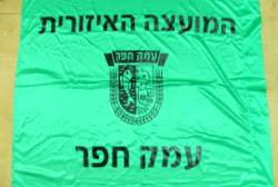
The unofficial flag above the city hall shows a black municipal
emblem on a green field.
Sources: author's own observation, 6 September 2001; this
webpage [retrieved].
The municipal emblem was published in the official gazette (Rashumot),
YP 633, 13 November 1958.
Dov Gutterman, 10 September 2001
First community (Kefar Wittkin) was founded in 1933 and today
it governs 27 Moshavim, 9 Kibbutzim, 5 Education
institutes, 4 communities and 2 neighborhoods.
The emblem includes a fish and orange tree inside of two spikes.
Source: www.hefer.org.il [retrieved].
Dov Gutterman, 1 May 2005
The Hefer Valley Regional Council was the first Regional Council established in the country in 1940
encompassing a total of 44 (other sources mention 45) localities – including moshavim, kibbutzim,
community settlements, neighborhoods, and educational institutions – with a population of
approximately 37'000 residents (as of 2010).
The first nucleus group attempting to settle in the valley – the Vitkin group – struggled against
Bedouin grazing in the area as it sought to establish its settlement. The Mandate police
removed the Bedouin; on 2 January 1930 a group comprising 20 members of the "Vitkin" and "Gimel-HaEmek"
organizations settled the site (other sources mention 1933 and even 1934) as Vitkin Village (Kfar
Vitkin). On 1 May 1932 a calling for organization members to settle was issued, and at the end of the
year the two organizations merged to form United Vitkin (Vitkin HaMeuhad).
The Council originated with the Hefer Valley Settlements Committee, which represented the area's
communities – though without municipal authority—starting in 1934.
In early 1938, as part of the Mandatory government's initiative to establish local councils for Jewish
settlements, discussions began regarding the creation of a local council encompassing all the Hefer Valley
communities – an initiative that was the first of its kind in the Land of Israel.
The Bloc Committee (Vad Gush) – a voluntary organization of the settlements in the Hefer
Valley area, became the first recognized Regional Council in Israel by the British Mandate government.
The establishment of the Regional Council in 1940 created, for the first time, in the rural area of Israel,
a new method of local government, was introduced among groups of settlements, most of which belong to the
"labor-oriented settlement sector" (i.e. Histadrut).
In December 1940, the council comprised 18 agricultural settlements and 4 workers' settlements, spanning
an area of 30'700 dunams and home to 4000 residents.
Sources:
kfar-vitkin.org.il [2021]
kfar-vitkin.org.il [2023]
https://he.wikipedia.org/wiki/...
https://he.wikipedia.org/wiki/...
https://he.wikipedia.org/wiki/...
https://www.nli.org.il/he/...
Esteban Rivera, 7 September 2026
![[CoA]](../images/i/il-emekhefer).png) image located by Esteban Rivera
image located by Esteban Rivera
(source,
source)
![[CoA]](../images/i/il-emekhef)old.gif)
![[logo]](../images/i/il-emekhef_logo.jpg)
(source)
.jpg) image located by Esteban Rivera
image located by Esteban Rivera