
Last modified: 2021-08-26 by  klaus-michael schneider
Keywords: ecuador | pichincha | quito | tumbaco |
Links: FOTW homepage |
search |
disclaimer and copyright |
write us |
mirrors
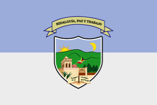 image by Ivan Sache, 12 June 2018
See also:
The parish of Tumbaco (49,944 inhabitants in 2010; 18,100 ha) is located 15
km east of Quito. Tumbaco is said to have been named after Cristina Tumbaco, the
widow of the last local chief (cacique), who offered plots to build the church
and the cemetery. The "donation" was indeed insinuated, if not forced, by the
missionaries of the Society of Jesus who owned the neighboring La Viña Estate.
The ecclesiastic parish of Nuestra Señora de la Limpia Concepci¾n was elevated
on 8 December 1670. In the 18th century, Juan de Lima listed Tumbaco among the
25 main villages forming the corregimiento of Quito.
The civil parish of Tumbaco was established in 1861, as part of the canton of
Quito.
Source: Parish website
Ivan Sache, 12 June 2018
The flag of Tumbaco is horizontally divided celestial blue-light gray with
the parish coat of arms in the center.
Source:
Municipal website
The emblem features one of the two parish churches of Tumbaco, erected from 1575
to 1600.
Photo:
https://lucias2011.wordpress.com
Ivan Sache, 12 June 2018