
Last modified: 2012-08-09 by rob raeside
Keywords: saskatchewan | benson rural municipality |
Links: FOTW homepage |
search |
disclaimer and copyright |
write us |
mirrors
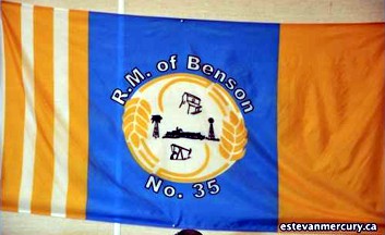 image located by Valentin Poposki, 10 July 2011
See also:
Rural Municipality of Benson confirmed that it has a flag, but has no
image, picture or documentation to send me.
Valentin Poposki, 25 March 2010
"Benson No. 35 (2006 Population 434 ) is a rural municipality in south-east
Saskatchewan, Canada encompassing 836.39 square kilometers in area. The rural
municipality has within its boundaries the communities of Benson and Bryant,
Saskatchewan. The rural municipality maintains offices in the community of
Benson. The rural municipality in conjunction with the provincial government is
in charge of maintenance of highways in its area. As well, the municipality
provides policing, fire protection and municipal governance for the rural
district, with a reeve as its administrator. The rural municipality was
established on December 13, 1909. Agriculture plays an important role in the
rural municipality with 207,200 acres (95%) of land in under cultivation. There
are also 300 oil wells in the municipality." - from Wikipedia:
http://en.wikipedia.org/wiki/Benson_No._35,_Saskatchewan
Following
the celebration of its centennial in 2009, the RM of Benson No.35 adopted a flag
which is vertically divided in three fields - the first field consists of 7
vertical stripes (4 orange and 3 white), the central blue field contains the RM
emblem encircled by the words ""R. M. of Benson / No. 35", and the third field
is plain orange:
http://www.estevanmercury.ca/apps/pbcs.dll/tngallery?Site=GN&Date=20100805&Category=estmercury&ArtNo=805009997&Ref=PH,
click on a photo for larger view.
Valentin Poposki, 10 July 2011