
Last modified: 2020-07-12 by ian macdonald
Keywords: rio grande do sul | ajuricaba |
Links: FOTW homepage |
search |
disclaimer and copyright |
write us |
mirrors
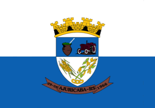 image by Paulo RS Menezes, 29 May 2014
Source:
http://commons.wikimedia.org/wiki/Category:Flags_of_municipalities_of_Rio_Grande_do_Sul
Based on
http://www.ajuricaba.rs.gov.br/paginas/dados_historicos, the municipality of
Ajuricaba (7,255 inhabitants in 2010; 32,324 ha) is located 30 km north-west of
Ijui and 450 km north-west of Porto Alegre. Ajuricaba is named for an Amazonian
cacique of the Manaos tribes. In the beginning of the 17th century, he set up an
alliance with the Dutch against the Portuguese. To prevent a Dutch invasion of
the Rio Negro valley, the Portuguese attacked Manaos. Captured in 1727,
Ajuricaba committed suicide by drowning during his transfer to Belťm. Ajuricaba
has remained an archetypical freedom fighter both for the natives and the
Portuguese.
Ajuricaba was established by German and Italian immigrants,
coming from old colonies of Rio Grande do Sul, such as Bento GonÁalves and S„o
Leopoldo. The new colony, established on 19 October 1890, as ColŰnia de Ijuhy
Grande, was the first of the new colonies founded in north-western Rio Grande do
Sul. The colony, originally divided into "lines", was subsequently organized in
districts and renamed Ajuricaba in January 1940. The municipality of Ajuricaba
was established on 8 November 1965 by Decree-Law No. 5,085 and inaugurated on 29
May 1966, with its seat at Linha 19.
Ivan Sache, 31 May 2014
The flag and arms of Ajuricaba are prescribed by Law no. 237
promulgated on 10 May 1978.
Article 1.
The flag of the municipality of
Ajuricaba is composed of two equal rectangles, the upper, white, and the lower,
celestial blue, and charged in the center with the municipal coat of arms.
Article 2.
The coat of arms of the municipality of Ajuricaba is composed
of a shield surmounted by a four-towered mural crown or, representing a "cidade".
The shield is divided into two parts; the upper part, celestial blue and charged
with a mate calabash - symbolizing one of the sources of income of the
municipality and its hospitality tradition - and a tractor, which symbolizes
agriculture and its high level of mechanization; the lower part, white, charged
with a soybean plant and a wheat plant superimposed to three chain links,
symbolizing, the forts, the main source of income of the municipality, and the
second, union and cooperativism, which are the bases of the economy. Beneath the
shield, a brown scroll inscribed argent: 29.05 - AJURICABA - RS - 1966".
https://leismunicipais.com.br/a/rs/a/ajuricaba/lei-ordinaria/1978/24/237/lei-ordinaria-n-237-1978-institui-a-bandeira-e-o-brasao-do-municipio-de-ajuricaba
- Leis Municipais database
Photos"
https://www.ajuricaba.rs.gov.br/paginas/dados_historicos ("Based on..." has
to be removed from the first paragraph)
http://www.jmijui.com.br/noticia/58/ajuricaba-recebe-repasse-para-cobertura-praca
Ivan Sache,
11 July 2020