
Last modified: 2012-03-17 by ian macdonald
Keywords: minas gerais | matias barbosa |
Links: FOTW homepage |
search |
disclaimer and copyright |
write us |
mirrors
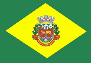 image by
Dirk Schönberger, 3 August 2010
image by
Dirk Schönberger, 3 August 2010
Source:
adapted from
http://cid-57cc02038c003794.office.live.com/self.aspx/.Documents
A green flag, bearing a large yellow diamond, with the municipal arms in the center.
Official site at
http://www.matiasbarbosa.mg.gov.br/
The flag was adapted from
andregoth's data at
http://cid-57cc02038c003794.office.live.com/self.aspx/.Documents
Dirk Schönberger,
2 August 2010
The municipality of Matias Barbosa (13,435 inhabitants in 2010; 157 sq.
km) is located in southern Minas Gerais, 300 km of Belo Horizonte.
Matias
Barbosa originates in a domain ("sesmaria") granted in 1709, therefore one of
the oldest in the region, to Mathias Barboza da Silva. The "Caminho Novo"
(New Trail) was inaugurated the same year. The "Registro" (tax post) of
Matias Barbosa was a mandatory stopping place where tax on gold and diamond
transported to Rio de Janeiro was perceived. After Barboza's death, the tax
post was sold to Colonel Manuel do Valle Amado, who increased it. The "União
& Indústria" company built the first macadamized road in South America to
ship coffee, with Matias Barbosa as a post for carts and stagecoaches. The
carts were succeeded by the trains of the Imperial Railway, with a station
built in Matias Barbosa and inaugurated by Emperor Peter II in 1875. The
urban nucleus of the town moved near the station.
The symbols of
Matias Barbosa, designed by Pr. Newton Barbosa de Castro, are prescribed by
Municipal Law No. 663 of 21 September 2001, superseding Law No. 240 of 27
March 1986.
The shield is Portuguese or Iberic, as use predominantly in
the civic heraldry in Brazil, reflecting our remote Lusitanian origins.
The chief is made of mountains wavy vert (green) symbolizing the local
landscape. The fess or (golden yellow) recalls the "Caminho Novo" (New
Trail), the first way of communication in the region, linking Rio de Janeiro
to the mining districts. The chief is charged in the middle with a chapel
representing the chapel dedicated to Nossa Senhora da Conceição do Registro
do Caminho Novo, recalling the tax office that existed in Manuel do Vale
Amado's estate, then a mandatory place of tax perception. In 1781, he was
granted the office of Commander of the Patrol of the Caminho Novo, for three
years. The facade of the chapel is depicted, the single and last remaining
building from the 18th century in the region, built in 1777. The "inconfidentes"
rebels, including Colonel Francisco de Paula Freire de Andrade. used to pray
in the chapel on their way to Rio. The chief is charged dexter with an
escutcheon argent charged with a pioneer ("bandeirante")'s cloak gules (red)
as a tribute to the pioneers who built the "Caminho Novo". The chief is
charged sinister with an escutcheon argent charged with a triangle gules
(red) recalling Tiradentes, who owned three estates in the region, and the
rebels who stayed overnight in Manuel do Vale Amado's estate and prayed in
the chapel.
The field is gules with a depiction of the Zamba bridge
argent as it was originally made (with wooden superstructure) and with stone
pillars also as it was originally). The bridge was built for the Parabuina road
by Henrique Guilherme Fernando Halfeld. It was also used by the road built by
the "União e Indústria" company, owned by Mariano Procópio Ferreira Lage. The
bridge symbolizes two roads that contributed, together with the "Caminho Novo",
to the development of the region. On the bridge is a cart transporting coffee
for the "União e Indústria" company, drawn by two mules, the whole or (golden
yellow) to highlight coffee as the main resource of the region, or "green gold".
River Paraibuna is represented as fesses wavy sable (black)
and argent. According to Antenor Nascentes, Paraibuna ("para" + "iwa" + "uma")
means in native language "a worthless, dark river". The river was indeed used as
a main way of communication. The base of the shield is vert (green), charged
with a beef cattle's head argent, surrounded by two maize cobs fructed or
(golden yellow). The whole symbolizes agriculture and cattle-breeding on a
greening land, watered by the Paraibuna, conducive to agriculture and
cattle-breeding.
The shield is surmounted by an eight-towered mural crown
argent, the heraldic symbols of municipalities with the rank of "cidade". The gates gules represent the commitment of the town to
welcome everybody looking for a safe shelter. The shield is supported by
branches of coffee fructed, recalling the most important economical activity in
the region. The scroll gules (red) is inscribed in or (golden yellow), dexter,
"1709", the year Matias Barbosa was granted the piece of land on which the
municipality named for him would develop, sinister, "7/9/1923", the date of
secession from Juiz de Fora, in the middle, the name of the municipality.
http://www.matiasbarbosa.mg.gov.br/index.php?option=com_content&view=article&id=72&Itemid=372
- Municipal website
Ivan Sache, 5 February 2012