
Last modified: 2022-06-25 by rob raeside
Keywords: northumberland | england |
Links: FOTW homepage |
search |
disclaimer and copyright |
write us |
mirrors
![[Northumbria]](../images/g/gb-nthum.gif) image by Thanh-Tâm Lê, 13 March 1999
image by Thanh-Tâm Lê, 13 March 1999
Northumberland is a unitary authority and historic county in Northeast England. It is the northernmost county of England. It shares borders with the three counties of Cumbria, County Durham, and Tyne & Wear. Scotland borders it to the north and it has 64 miles of coastline on the North Sea. The county seat or town is Alnwick. The Northumberland County Council resides in town of Morpeth. It is said that Northumberland is the least densely populated county in England, and its undeveloped high moorlands are protected as the Northumberland National Park.
Historically, because of its location, Northumberland has been the site of a number of battles and power struggles. In Roman times it lay north of Hadrian's Wall, except for a brief period when the Romans extended their power north to build the Antonine Wall. In Anglo-Saxon times during the 7th century it was known as the Kingdom of Northumbria. Their most famous king was Edwin (616-633) whose lands stretched from the Humber in the south to the Firth of Forth in the north. The Picts, however, gradually reclaimed most of the land as the Saxon kingdom lost power. Bamburgh is the historic capital of Northumberland, the royal castle from before the unification of the Kingdoms of England under the monarchs of the House of Wessex in the 10th century. In 1018, the northern part of Northumbria was ceded to the Kingdom of Scotland. The area of Northumberland has a long history of revolt and rebellion against government power of England, usually led by the Earls of Northumberland, the Percy family. An good example would be the Rising of the North (1569-1570) against Elizabeth I of England.
During the Industrial Revolution in the 18th century the coal deposits in Northumberland played a major role in the industrial development in other areas of Britain. The first rail development came from the need to transport the coal from Northumberland to the south of England. Although shipbuilding and armaments manufacture became important industries during the two great wars, Northumberland still remains largely rural. In recent years the county's scenic beauty and its historical sites have attracted considerable tourism.
There exists considerable confusion among outsiders about the difference between Northumbria and Northumberland. Originally Northumbria
was the name of a historic kingdom of Angles in medieval England, and the earldom which succeeded it. Before 1066, Northumbria was everywhere in England North of the Humber and York was the capital of it. Eventually the area was made the county of Northumberland, but was still mainly the area located around Newcastle. Yorkshire, Durham and Westmorland became separate counties. When they re-organized the counties in 1974, Westmorland County got carved up between Northumberland and Cumberland, Tyne and Wear escaped to become a county and Cleveland (the area of Teesdale) was badly sliced up. To further confuse things, they thought they should give
to the new areas they formed a new name, but instead went back to Northumberland, which is an old name - so absolutely no reason you should be confused... The people who live there know where they live.
Pete Loeser, 25 November 2020
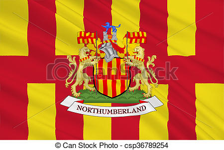
Northumberland exists as a county and the flag is based on the arms granted to the Council in 1951. In 1996 it was said to be flying in 200 locations within the county.
David Prothero, 22 June 2001
The following information appeared on the website of Northumberland County Council:
The Northumberland flag is based on a traditional flag which is probably the oldest known flag design in Britain. The Venerable Bede, England's first historian, records a banner of purple and gold which hung over the tomb of St. Oswald, the 7th century king of Northumbria. The flag for this ancient kingdom is now generally regarded as having 8 alternate stripes of red and gold. Later, in medieval times, the colours were adopted by the first Earl of Northumberland. The present pattern was granted to Northumberland County Council as its own banner in 1951. In November 1995, the Council took the historic decision for its own flag to become the flag for the modern day County of Northumberland; and it has rapidly been adopted as a symbol for the County by a wide range of businesses and individuals.Thanh-Tâm Lê, 13 March 1999
The following item appeared in the Newcastle Journal of 1 February 2000:
David C. Fowler, 1 February 2000The flag of Bernicia has eight stripes alternating red and gold and as Mr. Wilson points out, Bernicia was the ancient Angle Kingdom which stretched from the Tees to the Forth. The Northumberland flag, however, used the traditional flag as its model to create a new flag which can only be flown in the present, modern County of Northumberland.
This flag was granted to the council as part of its arms in December 1951, and on 15 November 1995 the county council made the historic decision to permit the flying of this flag anywhere within the present county and to register this "new" flag with the United Kingdom Flag Institute.
It fulfils a 1,200-year tradition in which the county has been associated with the colours red and gold. As described in the history, the Northumberland flag should only be rightfully flown within the present administrative County of Northumberland (e.g. not Newcastle or Whitley Bay). It should not, for example, be flown by a Northumberland company at their distribution depot outside the county.
The flag may be flown on any appropriate flagpole within the county by businesses, voluntary organisations and individuals.
Coun. Peter Hillman, Spokesperson for Community Services, Northumberland County Council.
According to an article by William Crampton in Flagmaster 083 (1996) the flag has the traditional pales of Northumberland interlocked to represent the stones of the Roman wall. Each pale should be outlined separately, but in practice this is rarely, if ever done.
David Prothero, 25 September 2001
![[Northumberland 1:2 ratio Flag]](../images/g/gb-nthu2.gif) image by M. Schmöger
image by M. Schmöger
The Northumberland flag is also seen in the dimensions 1:2.
M. Schmöger
![[Northumberland Coat of Arms ]](../images/g/gb-nthum-coa.gif) image located by Pete Loeser, 25 November 2020
image located by Pete Loeser, 25 November 2020
"The arms were granted on December 4, 1951. Before this the council used the attributed arms of the Kingdom of Bernicia - 'paly of eight Or and gules'. In the official grant this has been altered to represent Hadrian's Wall and the English / Scottish border. The crest is based on the old badge of the county Sheriffs. The blue lion with extended tail comes from the arms of the Percy family, Earls and Dukes of Northumberland. The supporters are gold lions from the attributed arms of King Oswald of Northumbria. The arms are repeated in the crest, in the banners held by the supporters and in the colours of the collars."
Source: Heraldry of the World: Northumberland County Council.
Pete Loeser, 25 November 2020
![[Northumberland County Council Flag Variant]](../images/g/gb-nthum-cc.gif) image by Pete Loeser, 25 November 2020
image by Pete Loeser, 25 November 2020
Based on this image of the flag.
This commercially made flag has been sold to the public and used as a flag representing the county of Northumberland.
Pete Loeser, 25 November 2020
![[Northumberland County Council Logo 1]](../images/g/gb-nthum-lo1.gif)
![[Northumberland County Council Logo 1]](../images/g/gb-nthum-lo2.gif) images located by Pete Loeser
images located by Pete Loeser
These are examples of the different logos used by the Northumberland County Council one their websites, letterheads, and publications.
Pete Loeser, 25 November 2020
![[Northumberland County Council Logo 1]](../images/g/gb-nthum-lo3.gif)
![[Northumberland County Council Logo 1]](../images/g/gb-nthum-lo4.gif) images located by Pete Loeser
images located by Pete Loeser
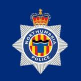
![[Northumbria Police]](../images/g/gb-nhuma-pd.gif) image by Pete Loeser, 25 November 2020
image by Pete Loeser, 25 November 2020
Department emblem based upon this image of their current badge.
The Northumberland Constabulary was the Home Office police force for the county of Northumberland from 1969 until 1974. In 1974 the Northumberland Constabulary was merged with the Durham Constabulary to become the Northumbria Police Department. They are now the territorial police force responsible for policing both the metropolitan county of Tyne and Wear and the ceremonial county of Northumberland. This includes the the city of Newcastle upon Tyne.
Pete Loeser, 25 November 2020
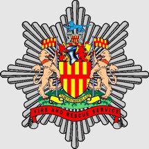
![[Northumberland Fire and Rescue Service]](../images/g/gb-nthum-fir.gif) image by Pete Loeser, 25 November 2020
image by Pete Loeser, 25 November 2020
Department emblem based upon this image of their current badge.
The 16 fire stations of the Northumberland Fire and Rescue Service cover the whole area of the Northumberland County. This is an area of approximately 1,941 square miles with a population of 316,028+ people (in 2020). Their Department headquarters is located in the West Hartford Community Fire Station in Cramlington.
Pete Loeser, 25 November 2020