
This page is part of © FOTW Flags Of The World website
Duvergķ, Independencia (Dominican Republic)
Last modified: 2015-12-29 by randy young
Keywords: dominican republic | duvergķ | independencia | bicolor: horizontal (light blue-green) | coat of arms |
Links: FOTW homepage |
search |
disclaimer and copyright |
write us |
mirrors
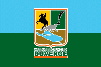
image by Randy Young, 29 December 2015
 - indicates flag is known.
 - indicates it is reported that there is no known flag.
Municipal district flags in Duvergķ:
See also:
- Puerto Escondido
- Vengan a Ver
See also:
The current flag of Duvergķ can be found in photographs on the municipality's Facebook page.The flag is being carried at the front of a parade. It is a horizontal bicolor, with light blue on top and dark green on the bottom half. Centered on the bisected field is the municipal coat of arms, fimbriated white. The shield is outlined in orange, with a white internal fimbriation, and is divided into three quarters. The top half of the shield is divided in half, with the left half showing the black silhouette of a martial figure holding aloft a sword and sitting upon a rearing horse, all on a gold field, while the right half shows a black silhouette of a quill in an ink well against a dark green field. The bottom half of the shield shows a light blue map of Lake Enriquillo against a brown field. At the center of the shield, over all, is a grey silhouette of an iguana. Below the shield in dark green letters fimbriated white are the words "AYUNTAMIENTO MUNICIPIO" and "DUVERG╔" in two separate lines. The name of the city is in larger letters, and sits upon an orange horizontal line.
Randy Young, 29 December 2015
Duvergķ is the largest city in Independencia province, along the southern border with Haiti. The settlement was founded in 1772 as the village of "Las Damas," and was elevated to municipality status in 1891 when it was renamed in honor of Antonio Duvergķ, a hero of the Dominican war of independence. Since that time, the municipality has changed hands between provinces multiple times, being at times part of Barahona (1891-1943), Baoruco (1943-1949), and finally Independencia (1949-present).
Source: Wikipedia article
Randy Young, 29 December 2015
Additionally, the municipality appears to have had a previous flag as recently as July 2010, seen in photographs here. This flag shows a different coat of arms centered on a plain white field. According to the text on the page, the top left of the coat of arms shows the Monument to the Heroes of the Battle of Baitoas, the top right shows the quill and ink as with the current coat of arms, and the bottom half of the shield is a reproduction of a map fragment from 1730 first showing the area and the rivers that flow into Lake Enriquillo. Below the shield is a red ribbon with the name of the municipality in black capital letters.
Randy Young, 29 December 2015