
Last modified: 2012-12-29 by ian macdonald
Keywords: sao paulo | jundiai | cogwheel | fortress |
Links: FOTW homepage |
search |
disclaimer and copyright |
write us |
mirrors
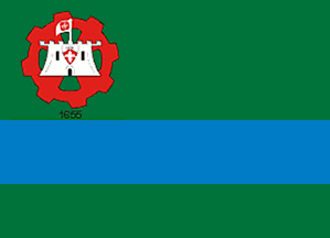 image by Dirk Schönberger,
28 November 2012
image by Dirk Schönberger,
28 November 2012
Source:
http://www.josebonifacio.sp.gov.br/nossa_cidade/nossa-historia
Other sites:
Jundiai is named for the river of the same name, itself named for the "jundiai" fish - South American catfish, Rhamdia quelen. The first Portuguese colonizers settled the region around 1615. The parish of Nossa Senhora de Desterro was founded by Rafael de Oliveira and Petronilha Rodrigues Antunes, who had fled São Paulo for political reasons. The parish was made a "vila" on 14 December 1655. Until the middle of the 19th century, the town remained very small, with hardly four central streets, a chapel and an hospital. The "cidade" of Jundiai was established on 28 March 1865, favoured by the coffee boom. The Santos-Jundiai railway was inaugurated in 1867. The town became a strategic place, with the establishment of the Cia. Paulista de Estradas de Ferro (1872), of the Cia. Ituana (1873), of the Cia. Itatibense (1890) and of Cia. Bragantina (1891). Italian immigration was organized in the region by Antônio de Queiroz Telles, Count of Parnaíba, then President of the São Paulo Province. The Núcleo Colonial Barão de Jundiai was established on 4 October 1886 on the site of today's Colônia borough. The first 22 colonists were soon joined by some 100 other. The main emblem of the early colony was a big fig tree.
The flag of Jundiai, designed by Diógenes Duarte Paes, is prescribed by Law No. 904 of 9 May 1961. The flag is horizontally divided green-blue-green (2:1:1:1) with an emblem (not the municipal coat of arms) in canton. The emblem shows a red cogwheel charged with a white fortress placed over a green cross. Below the emblem is the year "1655", in black. The blue stripe represents river Jundiai. The green field represents the Jundiai Mato Grosso and wine-growing. The red, green and white colours are a reference to the Italian immigrants. Number "1655" recalls the foundation year of the town.
The cogwheel, representing industry, and the fortress are taken from the municipal coat of arms, designed by Afonso d´Escragnolle Taunay*. The author intended to represent the town as "The Gate to Hinterland" ("porta do sertão") and an "advanced post of the civilized".
http://cidade.jundiai.sp.gov.br/pmjsite/portal.nsf/V03.02/cidade_simbolos?OpenDocument - Municipal website
*Afonso d'Escragnolle Taunay (1876-1958) was a genealogist, lexicographer and historian, noted for his studies on the São Paulo pioneers ("História geral das bandeiras paulistas", 11 volumes, 1924-1950) and coffee cultivation in Brazil ("História do café no Brasil", 11 volumes, 1929-1941). He was elected in 1929 at the Brazilian Academy of Letters.
http://www.academia.org.br/abl/cgi/cgilua.exe/sys/start.htm?sid=88 - Website of the Brazilian Academy of Letters
Photos of the flag:
http://saladeimprensa.jundiai.sp.gov.br/PMJSITE/noticiasPMJv2.nsf/0/8E8AAEF0818326EA83257A72004FE858/$file/Desfile7_de_Setembro_M17_g.jpg?OpenElement
http://www.panoramio.com/photo/9732959
Ivan Sache, 1 December 2012