
Last modified: 2021-12-04 by ian macdonald
Keywords: santa catarina | bandeirante |
Links: FOTW homepage |
search |
disclaimer and copyright |
write us |
mirrors
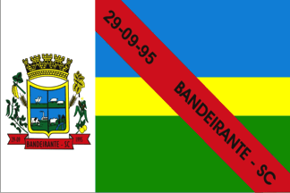 image by Ivan Sache, 1 November 2021
The municipality of Bandeirante (3,177 inhabitants in 2000; 14,626 ha) is
located on the border with Argentina, 670 km west of Florianópolis. The
municipality is composed of the town of Bandeirante (seat) and of the
communities of Linha Gaspar, Linha Prata, Linha Riqueza do Oeste, Linha Hélio
Wassum, Linha Reno, Linha Várzea Alegre, Linha Getúlio Vargas, Linha Novo
Encantado, and Linha Adolfo Zigueli.
Bandeirante was established in 1944
by Italian and German colonists. The district of Bandeirante was established on
27 December 1956. The municipality of Bandeirantes was established on 28
September 1995.
https://www.bandeirante.sc.gov.br/
Municipal website
Ivan Sache, 1 November 2021
Vertically divided 1:3, a white hoist stripe and the remainder horizontally divided blue over yellow over green, 2-1-2, with a red diagonal bearing the name in black per bend across the coloured fields, and with the municipal arms in the white stripe.
Official website at
http://www.bandeirante.sc.gov.br
Dirk Schönberger, 18 May 2012
Image from the municipal website
https://www.bandeirante.sc.gov.br/cms/pagina/ver/codMapaItem/43375
Ivan Sache, 1 November 2021