
Last modified: 2020-07-18 by ian macdonald
Keywords: rio grande do sul | ernestina |
Links: FOTW homepage |
search |
disclaimer and copyright |
write us |
mirrors
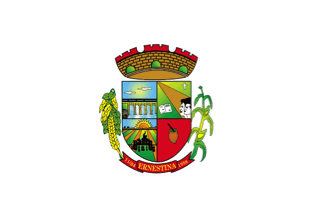 image by Ivan Sache, 17 July 2020
The municipality of Ernestina (3,202 inhabitants in 2014; 23,910 ha) is
located 220 km of Porto Alegre.
Ernestina was named for Ernestina Kruel
Niederauer (1889-1963; better known to her relatives as Pepita). On 30 December
1903, Pepita married Adolfo Schell Lourero; her father in law, AntŰnio Josť da
Silva Loureiro, known as the Baron, offered her a domain as her dowry. Adolfo
and Jo„o Fernando Kruel, Ernestina's uncle, split the domain into urban and
rural plots; ColŰnia Ernestina was registered in 1910 with the Directorate of
Land and Colonization.
ColŰnia Ernestina was elevated to the 11th district of
Passo Fundo by Municipal Act No. 398 issued on 14 July 1924. The district's name
was shortened to Ernestina by Municipal Act No. 431 issued on 14 July 1926.
On 13 April 1950, Jo„o Fernando Kruel and his wife, Aurora Shell Loureiro,
offered the plot where the central square of the town of Ernestina would be
built. The municipality of Ernestina was established by State Law No. 5,554
issued on 11 April 1988, and inaugurated on 1 January 1989.
https://ernestina.rs.gov.br/
Municipal website
Ivan Sache, 17 July 2020
The flag places the coat of arms on a white field.
Ivan Sache, 17 July 2020