
Last modified: 2012-02-11 by ian macdonald
Keywords: ceará | varjota |
Links: FOTW homepage |
search |
disclaimer and copyright |
write us |
mirrors
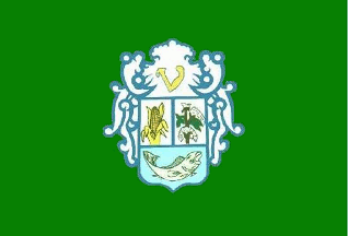 image by Dirk Schönberger,
15 March
2010
image by Dirk Schönberger,
15 March
2010
Based on http://www.varjota.ce.gov.br
A green flag with the municipal arms centerd.
Official website at http://www.varjota.ce.gov.br. The flag is only linked to on Wikipedia, the link points to http://www.aprece.org.br/site/downloads/BANDEIRADOMUNICPIO_68711237931235.jpg.
Dirk Schönberger, 15 March 2010
The municipality of Varjota (17,087 inhabitants in 2007; 179 sq. km) is
located in northwestern Ceará, 230 km of Fortaleza.
Varjota emerged as an
old estate founded by Father Macário Bezerra, from Ipú, on the flood plain ("varzea")
of brook Mucambo, a tributary of River Acaraú. A chapel dedicated to St. Ann
was built in 1834-1840 by the first settlers - from the Bezerra, Martins,
Melo and Araújo families. The early settlement increased with time, forming
the village of Varjota. in 1936, Varjota was incorporated to the
municipality of Santa Cruz do Norte, today's Reriutaba, forming in 1946 one
of its districts. In 1952, the State Governor launched the building of the
Paulo Sarasate barrage, then the biggest in Nordeste. When the rumor spread
that the barrage would flood Varjota, the inhabitants abandoned the village
and built a provisory camp close to the barrage. In April 1954, Varjota was
flooded and abandoned following the set up of the Ararinha barrage, used to
provide water to the bigger Araras barrage.
The flag of Varjota was
designed in 1986 by Evandro Leal Colaço, "respecting the traditions of
heraldry". The designer, of remote, unknown origin, worked for the municipal
administration when Varjota was made a municipality. Then he left and nobody
ever heard anything on or from him.
http://www.varjota.ce.gov.br/portal/conteudo.php?pg=noticia&id=2721
The
coat of arms of Varjota was modernized in 2011. Half-tone blue outlines were
added. The letter "V" was modernized, made golden yellow with a golden
outline. The maize cob was also modernized, but in the same colors as before.
The cotton plant, no longer a main source of income, was replaced by a bunch
of grapes representing the North Araras Irrigated Area. The two plants were
placed on a beige background representing the fertile soil of the
municipality. The fish, originally a salt water fish, was replaced by the
most commonly freshwater fish found fish in the Paulo Sarasate barrage. The
blue background has a shade gradient, from light at the top to dark at the
bottom, representing the crystalline waters of the Araras barrage.
http://www.varjota.ce.gov.br/portal/conteudo.php?pg=noticia&id=2722
The
municipal website shows a "photo" of the flag with the amended coat of arms,
but I am not sure this is a real photo of a real flag.
Ivan Sache,
16 January 2012