
Last modified: 2020-01-30 by ivan sache
Keywords: nieuwpoort |
Links: FOTW homepage |
search |
disclaimer and copyright |
write us |
mirrors
![[Flag]](../images/b/be-vwvnw.gif)
Flag of Nieuwpoort - Image by Arnaud Leroy, 11 September 2005
See also:
The municipality of Nieuwpoort (in French, Nieuport; 10,940 inhabitants on 1 January 2007; 3,100 ha; municipal website) is located 10 km south of Ostende, in the region of Flanders called
Westhoek. The municipality of Nieuwpoort was established in 1970 as the merger of the former municipalities of Nieuwpoort, Ramskapelle and Sint-Joris.
The village of Nieuwpoort proper is not located on the sea shore, but
the municipality is mostly popular for its sea resort, Nieuwpoort-Bad,
built from 1864 to 1893 by Baron Benjamin Crombez, owner of the lands
on the sea shore.
In the 5th-6th centuries, coastal Belgian was flooded during the event
known as the second Flandrian transgression. Only a row of islands
covered with dunes emerged from the sea. The sea withdrew three
centuries later but it does not seem that the Frankish tribes
immediatly colonized the islands.
After the building of the first settlements in Lo (841), Alveringem (857) and Veurne (860), a dyke was built along the beach in order to protect the low land from the sea. At the end of the 9th century, the main hazard was no longer the sea but the Northmen, who landed in
the mouth of river Yser (Isera Portus) in 861 and 881-885 and scoured
the region. In the 11th century, the third Flandrian transgression,
although limited, flooded Westhoek up to Diksmuide. The inhabitants
moved up to the sand hills, which were probably never flooded. The
abbeys of Koksijde and Oudenburg organized the building of new dykes and new villages were founded, such as Oostduinkerke (1080) and Ramaskapelle (1120). The space left between the dunes was filled up
with alluvial deposits, which built up the prés salés (salted
pastures), particularly suitable for sheep breeding.
The place name of Zandhoofd also appeared at the end of the 11th
century. Its old form was Sandeshoved (Sandy Head), referring to the
dunes protected by the dyke. In 1085, Abbot Inglebrecht from St.
Winok's abbey in Bergues (today in northern France) exchanged with
Robert de Fries an estate located in "Sandashovad". In 1108, Count
Robrecht offered to the abbey of Broekburg a pré salé called
"Sandashovad". Pope Calixtus II mentioned "Sandeshove" in a bull dated
1120. In 1183, the inhabitants of "Sandeshove" wrote to Pope Lucius
III. For decades (for instance in 1274 and 1365), the village was known
under the two names of Sandeshove and Nieuwpoort, although the latter
name had became official. Nieuwpoort appeared as Isera Portus (1150) and
Neoportus of Novum Oppidum (1163). This "new port" superseded the
ancient port town of Lombardsijde, located on the silted up northern
arm of the Yser, when Count of Flanders Philip of Alsace founded a
new town incorporating Zandhoofd. The new town was built with
rectilinear streets, ramparts and fortifications. In 1163, the count
granted a charter (Vrijheidskeure of Stadskeure van Nieuwpoort) and a
name to the town, Novus Portus.
Until the founding of the sea resort, Nieuwpoort mostly lived from
fishing, being once the most important fishing port in Belgium. The
1163 charter gives the tax base for herring, mackerel, salmon, fresh cod,
haddock, plaice, flounder, ray and eel. The Vierboete, built in 1284,
was probably the first lighthouse ever built in Europe.
As a port town, Nieuwpoort was often besieged, siezed and plundered, for
instance by the French in 1213, 1299 and 1328, and the troops from
Ghent in 1383.
In 1489, the town was besieged by the French and their allies from
Bruges, but the attackers were repelled. Mayor Jan Turpin asked the
women of the town to join the fight; Mathias Reynoudt said that those
women fought as bravely (soo cloeckelijkcke) as the
Amazons. The giant Jan Turpin II, built in 1963, is 10.60 m high,
requiring 24 porters, which is a record in Europe.
In 1600 took place the famous battle of Nieuwpoort. The port, along
with neighbouring Dunkirk, was then a den of Spanish pirates, who
scoured the North Sea and captured the Dutch ships. Maurice of Nassau
set up a punitive expedition which ended in Nieuwpoort. On 1 July, the
Dutch reached the northern shore of Yser. On the southern shore of the
river, Archduke Albert gathered in Oudenburg a big army. Maurice
cancelled the attack of Nieuwpoort and marched against Albert. On 2
July, the Dutch defeated the Spaniards in the dunes of Lombardsijde and
Westende. Nassau withdrew to Ostende but came back to Nieuwpoort on 5
July, where he was awaited by Albert's troops. The Dutch besieged the
town but did not attack it, and withdrew after one week of unsuccessful
siege.
The port of Nieuwpoort is linked to the sea by a 2-km long channel,
which can be crossed in Nieuwpoort-Bad with a ferry. The channel is
linked via the Ganzenpoot (Goose's Leg) lock to a complex network of
canals used for sailing and polder management.
During the First World War, King Albert I called the Belgians to
protect the last part of Belgium not invaded by the Germans, limited by
the river Yser and the sea. Karel Cogge, from Veurne, who was the
manager of the Noordwatering irrigation system, and the seaman Hendrik
Geeraert, from Nieuwpoort, worked together to flood the plain, forcing
the Germans to withdraw. The town of Nieuwpoort was shelled by the
German artillery and nearly destroyed, but the front line was
stabilized until the victorious breakout by the allied troops in 1918.
After the war, the sea resort was rebuilt in the so-called Westkust
(West Coast) style, whose best example is the house De Barkentijn,
built for Baron Crombez in 1923. The two piers of Nieuwpoort-Bad
(Western pier, 490 m; Eastern pier, 543 m) were completely rebuilt
after the Second World War.
The marina of Nieuwpoort (Eurojachthaven) is the biggest marina in northern Europe, with some 2,000 mooring spaces (450 in the "Vlotkom", main basin; 300 in the "Noorderhaven", northern port; and 1,200 in the "Novus Portus", new port). There are three yacht clubs in Nieuwpoort, VVW, WSKLuM and KYCN.
Ivan Sache, 11 September 2005
The municipal flag of Nieuwpoort is yellow with a lion standing in a
boat and holding an axe. All the elements are black except the tongue
of the lion, which is red.
According to Gemeentewapens in België - Vlaanderen en Brussel [w2v02a], the flag, adopted on 24 November 1981 by the Municipal Council, is prescribed by a Decree issued on 5 November 1984 by the Executive of Flanders, and published in the Belgian official gazette on 8 July and 17 October 1986.
The flag is a banner of the municipal arms.
The arms of Nieuwpoort are already shown by Servais (1955) [svm55] and were therefore not changed after the incorporation of Ramskapelle and Sint-Joris in 1970. The colors of the arms and the lion are typically Flemish.
![[Flag]](../images/b/be-vwvn1.gif)
Old flag of Nieuwpoort - Image by Arnaud Leroy, 11 September 2005
A fairly old postcard (collection Jan Mertens) shows the flag of Nieuwpoort as vertically divided black-yellow with the municipal arms in the center. This is probably the flag used in Nieuwpoort before the official adoption of the municipal flag.
Arnaud Leroy, Pascal Vagnat, Jan Mertens & Ivan Sache, 11 September 2005
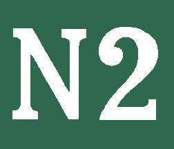
Nieuwpoort pilot flag - Image by Ivan Sache, 25 March 2019
Album des pavillons nationaux et des marques distinctives des marines de guerre et de commerce (1889) [f9r89] shows the Nieuwpoort pilot flag as green with "N2" in white.
Ivan Sache, 25 March 2019