
Last modified: 2022-02-05 by rob raeside
Keywords: amazonas | gobierno regional amazonas |
Links: FOTW homepage |
search |
disclaimer and copyright |
write us |
mirrors
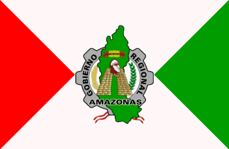 image by Juan Carlos Herrera and
António Martins, 05 October 2004
image by Juan Carlos Herrera and
António Martins, 05 October 2004
The Amazonas Region (375,993 inhabitants in 2007; 39,249 sq. km) is located
in north-western Peru, on the border with Ecuador. The region is divided into
the seven Provinces of Chacapoyas, Bagua, Bongará, Condorcanqui, Luya, Rodríguez
de Mendoza and Utcubamba.
Ivan Sache, 24 May 2010
In Chachapoyas, the capital of Amazonas, I saw the regional
[departmental] flag.
Juan Carlos Herrera, 16 August 2004
White flag with two right angle triangles with hypotenuses fitting the
edge of the flag — green at the fly, red at the hoist.
António Martins, 05 October 2004
The basic design of this flag, is similar to the
1825-1822 national flag of Peru,
per saltire red and white.
António Martins, 23 April 2006
I receive another communication with confirmation that department
of Amazonas don’t have flag (but I received before official information
about this “nonexistent” flag).
Jaume Ollé, 01 September 2000
The Amazonas flag and logo are presented on his blog (28 April 2008) by Mañuel
Cabanas Lopez, a former Secretary of the Regional Council.
The Amazonas flag was approved on 9 October 2003 by Regional Decree No.
010/2003, prescribing the flag to be officially hoisted on 21 November "in the
whole region". The red triangle, on the left, is a tribute to the martyrs who
offered their lives for freedom and the national sovereignty. The green
triangle, on the right, represents the Amazonian territory of the region and a
new dawn full of hope. White, in the middle, symbolized peace and the
integration of our people. The flag was initiated by the PR Agency of the first
Regional Government.
Ivan Sache, 24 May 2010
The Amazonas logo, placed in the middle of the flag, was approved by Regional
Decree No. 003-2003, with the following description: "Light green map of the
Region. In the upper part a crown of feathers, red and yellow, symbolizing the
Shuar nation. In the central part, a light brown trapezoid wall, surmounted by an
ocher head, representing the Chacapoya culture*. On the left side, a golden
yellow rice panicle representing the regional agriculture; on the right side, a
dark green branch of laurel symbolizing the tribute and everlasting homage to
the heroes and to all the children of the region who contributed to its
development. In the lower part, a red-white-red scroll as a sign of fidelity to
the Republic of Peru. In the background, a light gray wheel with seven cogs
representing the uity and the integration of the seven provinces of the region,
charged with the black writing "GOBIERNO REGIONAL AMAZONAS". The logo was
initiated in January 2003 by Mañuel Cabanas Lopez, Secretary of the Regional
Council, via memorandum No. 006-2003.
Source:
http://mcabanas.blogia.com/2008/042301-simbolos-regionales-de-amazonas.php
* The wall represented on the logo is the main gate of the Kuelap (lit., "The
Cold Place") fortress, built in the 10th century by the Chacapoyas (lit. the
Clouds' Warriors) at an elevation of 3,000 m asl.
Source: http://artslivres.com/ShowArticle.php?Id=1553
Ivan Sache, 24 May 2010