
Last modified: 2020-04-12 by rob raeside
Keywords: guyana | cuyuni-mazaruni |
Links: FOTW homepage |
search |
disclaimer and copyright |
write us |
mirrors
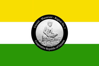 image located by Jason Saber, 7 June 2019
See also:
From "Emblems, Flags and Colours of the Regions of the Cooperative Republic
of Guyana", apparently published by the Government of Guyana.
Cuyuni-Mazaruni - Region No. 7
The Cuyuni-Mazaruni Region contains two of the
four natural regions: forested highlands and a small portion of the hilly sand
and clay region.
This Region brings to mind the majestic Pakaraima
mountain range. Mount Roraima (2,810 metres high, standing at the point where
Guyana, Brazil and Venezuela meet) and Mount Ayanganna are in this mountain
range.
Most of the 15,342 people of this Region are involved in mining
for gold and diamonds. Omai Gold Mines Ltd, which extracted 250,642 ounces of
gold last year [1994], is the biggest gold producer in this Region, and in
Guyana.
Under the Upper Mazaruni Hydroelectric Scheme, a hydroelectric
plant was to provide electricity for the Region was planned, but it has not yet
been built. It would be a great asset to the Region's development.
There
are eight Amerindian settlements in the area of the Pakaraimas, where crops are
grown. These crops supply the settlements and gold and diamond mines in the
Region.
Jason Saber, 7 June 2019
The colours of this flag are; yellow for the obvious and significant mineral
wealth, white for the water resources and green for the heavily forested areas.
The symbol is an illustration of traditional gold mining, a key economic earner
for the region and country.
Jason Saber, 7 June 2019
 image located by Jens Pattke, 9 June 2019
Source:
https://demerarawaves.com