
Last modified: 2021-08-26 by  klaus-michael schneider
Keywords: manabi | puerto lopez | lopez |
Links: FOTW homepage |
search |
disclaimer and copyright |
write us |
mirrors
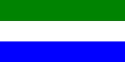 image by Pascal Gross, 23 June 2000
See also:
The canton was formed on 31 August 1994.
The flag and the coat of arms are shown as drawings on a PDF
document available on the website of the Association of
Ecuadorian Municipalities.
Ivan Sache, 18 October 2008
The flag of Puerto López is horizontally divided green-white-blue.
Green
represents the vegetation and the abundant agriculture of Machalilla National
Park*.
White represents the purity of the inhabitants and the legacy of the
pre-Colombian cultures, like Manteńa, Machalilla and Valdivia.
Blue
represents the sea, source of work and income for our people.
http://www.puertolopez.gob.ec/simbolos/
*Zona Marina Parque Nacional Machalilla. 14,430 ha.
A complex of shallow
coastal waters, sandy beaches and off-shore islands fringed by coral reefs. The
site includes the mouths of several seasonal rivers and streams and remnant dry
tropical forest. Archaeologically interesting with evidence of civilizations
dating from 3,000 B.C. to 1526 A.D. The area supports an important fishery,
provides habitat for a breeding colony of seabirds, and nesting beaches for
marine turtles. Human activities include subsistence agriculture, livestock
raising, and tree harvesting for firewood and charcoal.
https://rsis.ramsar.org/ris/503
Ramsar Sites Information Service
Ivan Sache, 14 September 2018
ma-pl.jpg)
image from <members.es.tripod.de>
(defunct), located by Pascal Gross, 23 June 2000