
Last modified: 2021-08-26 by  klaus-michael schneider
Keywords: manabi | mayo |
Links: FOTW homepage |
search |
disclaimer and copyright |
write us |
mirrors
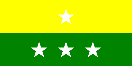 image by Pascal Gross, 23 June 2000
Parishes:
See also:
24 de Mayo canton (28,846 inhabitants in 2015; 189,396 ha) is located in the
south of Manabí province.
The canton was established on 15 February 1945.
Ivan Sache, 13 September 2018
The flag, which was designed by Bogomil Trámpuz Bratina, is bicolor, the
upper stripe, yellow, and the lower stripe, green; the two stripes are
horizontal, of the same width, 50 cm, and [overall] length, 100 cm.
The
yellow stripe represents golden wheat, the canton's source of income, while the
green stripe represents the vegetation of the fields
and fertile soils,
source of the crop resources.
The flag is charged with four stars
representing the parishes. Sucre, as the urban parish [and capital] is
represented by the star placed in the center of the yellow stripe. The three
stars in the green stripe
represents the three rural parishes: Noboa,
Bellavista and Sixto Duran.
http://www.24demayo.gob.ec/24mayo/index.php/24-de-mayo/simbolos-cantonales
Ivan Sache, 13 September 2018
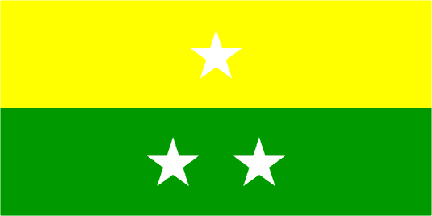 image by Dirk Schonberger, 29 October 2001
The canton originally had only two rural parishes, Noboa and Bellavista.
Ivan Sache, 13 September 2018
ma-my.jpg) image located by Pascal Gross, 23 June 2000
image located by Pascal Gross, 23 June 2000
from members.es.tripod.de (defunct)