
Last modified: 2021-12-11 by ian macdonald
Keywords: santa catarina | lebon régis |
Links: FOTW homepage |
search |
disclaimer and copyright |
write us |
mirrors
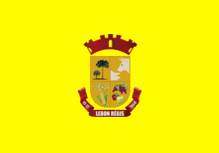 image by Ivan Sache,
4 November 2021
image by Ivan Sache,
4 November 2021
The municipality of Lebon Régis (12,133 inhabitants in 2018; 94,057 ha) is
located 360 km west of Florianópolis.
Lebon Régis was established in the
1950s as Santo Antônio do Trombudo. Located on the route used by tropeiros to
convey cattle between Curitibanos and Caçador, the settlement swiftly increased.
The district of Lebon Régis was established in 1938, to be elevated a
municipality by State Law No. 387 promulgated on 21 June 1950, merging with the
district of São Sebastião do Sul.
The municipality is named for General
Gustavo Lebon Régis, who was Secretary General of Santa Catarina State during
the Contestado War (1912-1916) and commanded the first attack against Taquaruçu,
one of the rebels' biggest stronghold.
Lebon Régis was proclaimed "Heart
of the Contestado" by State Law No. 1,766 promulgated on 10 January 2018. The
most significant battles of the conflict took place on the present-day's
municipal territory of Lebon Régis.
An airfield was built on Tapera do
Claudiano, part of the municipality, to attack the rebels in Santa Maria.
Aircrafts never landed there but were actually used from other airfields. The
Contestado War was therefore the first conflict in America where aviation was
uaed. Lieutenant Ricardo João Kirk was the first airman killed in action in
America.
https://www.lebonregis.sc.gov.br/
Municipal website
Ivan Sache, 4 November 2021
The flag of Lebon Régis is prescribed by Municipal Law No. 245 promulgated on
5 November 1980.
Article 1.
The municipal flag shall have the
following heraldic description. Composed of a cream field, charged in the center
with the municipal arms.
Article 2.
The design of the municipal flag
shall obey the following rules.
a) The length shall be 1.30 m and the width
90 cm.
https://leismunicipais.com.br/a/sc/l/lebon-regis/lei-ordinaria/1980/25/245/lei-ordinaria-n-245-1980-institui-a-bandeira-do-municipio-de-lebon-regis
Leis Municipais database
The coat of arms of Lebon Régis is composed
of an Iberian shield, with the point formed by a semi-circle, in use in Portugal
at the time of the discovery and colonization of Brazil. According to Brazilian
heraldists, this is the most appropriate shape for Brazilian towns. In Brazilian
heraldry, it evokes the origin of the race, whose formation was based on
Portuguese as its primary ethnical element.
The four-towered mural crown is
the proper and consecrated emblem of municipalities and their administrative
autonomy.
The Brazilian pine and the butia palm represent main sources of
income for the municipality in the past, timber extraction and butia industrial
cropping.
The stylized profiles of a pig's head and a bovine's head,
representing the base of local, in development, cattle-breeding.
The stylized
maize and soybean plants represent the new crops in Lebon Régis and their
significance for agricultural, as well as a promising future for farmers'
families development.
The stylized bunch of grape and apple represent fruit
cultivation, which is a source of income for the municipality.
Date "19
December 1958" represents the date of political and administrative emancipation
of Lebon Régis.
https://www.lebonregis.sc.gov.br/cms/pagina/ver/codMapaItem/50330
Municipal website
Photos
https://www.jornalextrasc.com.br/noticias/detalhes/prefeitura-de-lebon-regis-participa-de-missa-em-homenagem-ao-poder-publico-na-trezena-de-santo-antonio-3191
https://www.cacador.net/noticias/esporte/2018/12/10/conquista-xadrez-de-lebon-regis-e-campeao-da-18-olesc-41884
https://i2.wp.com/desacato.info/wp-content/uploads/2018/01/Prefeitura-de-Lebon-Régis-com-a-bandeira-do-Contestado-2017.jpg
https://www.facebook.com/prefeituralebonregis/photos/2999884363590174
https://radiofraiburgo.fm.br/lebon-regis-confirma-os-primeiros-casos-de-covid-19/
Ivan Sache, 4 November 2021