
Last modified: 2012-01-14 by ian macdonald
Keywords: mato grosso do sul | rio brilhante |
Links: FOTW homepage |
search |
disclaimer and copyright |
write us |
mirrors
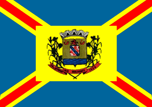 image by
Dirk Schönberger, 5 November 2010
image by
Dirk Schönberger, 5 November 2010
Source:
http://www.riobrilhante.ms.gov.br/site/index.php?acao=bandeiras
A blue flag with a yellow-fimbriated red saltire overlain by a central yellow rectangle bearing the municipal arms.
Official website at
http://www.riobrilhante.ms.gov.br/
Dirk Schönberger, 5 November 2010
The municipality of Rio Brilhante (27,435 inhabitants in 2008; 3,988 sq. km)
is located in the south-east of Mato Grosso do Sul, 160 km of Campo Grande. The
municipal territory is mostly limited by rivers Brilhante and Vacaria,
therefore its former name of Entre-Rios (Between Rivers).
In 1841,
Antônio Gonçalves Barbosa settled an area he named Boa Vista, located between
rivers Vacaria and Brilhante. He was followed by several gaúcho families
breeding cows, sheep and horses. In 1862, the region was deserted because of
its invasion by Paraguay. The region became subsequently a main zone of
production of yerba mate, as well as of gold extraction; the products were
exported via the rivers, then navigable. Modern agriculture was introduced in
the 1970s; Rio Brilhante is today the biggest producer of rice and the second
producer of sugarcane and oats in Mato Gross do Sul, as well as a main center
of sugar alcohol production. State Decree No. 611 of 10 July 1912 created the
Vacaria District, part of the Municipality of Campo Grande, with the
village of Entre-Rios as its capital. Law No. 1025 of 26 September 1929 granted
the title of "vila" (town) to Entre-Rios, capital of the municipality of the
same name, dismembered from Campo Grande. Decree-Law No. 545 of 31 December
1943 renamed the municipality Caiuás. The name of Rio Brilhante was eventually
prescribed by Law No. 136, 30 September 1948.
The flag of Rio Brilhante
is rectangular, with dimensions 0.86 m x 1.10 m. The blue rectangle represents
the rivers' waters. Four red rays emerging from the flag's center and reaching
its corner [that is, forming a saltire] symbolize the struggle to conquest the
land. Two smaller yellow rays flanking the red rays [that is, fimbriating the
red saltire] represent the gold rush's times in Rio Brilhante. The municipal
coat of arms is placed in the middle of the flag [on a yellow rectangle]. The
flag was authored by Arcinoé Antonio Pexoto de Faria, credited of several
municipal flags in Mato Grosso and Mato Grosso do Sul, and designed by José dos
Santos in 1976.
The shield is flanked by wheat, soybean and rice plants
tied under the shield,
representing significant crops in the municipality. The blue base of the
shield represents river Brilhante. Three red lions, two in the escutcheon
and one surmounting the shield, represent the courage of the Barbosa family,
pioneers of the municipality. The two "berrantes" (gaúcho's horns) recall
that cattle breeding was the base of the local economy. The shield is
surmounted by a mural crown recalling the medieval forts and the rule of Rio
Brilhante over the region. Yellow represents gold once extracted in the
region. A red scroll placed below the shield is charged with the name of the
municipality, flanked by the date of creation of the municipality (seemingly
26 September 1929), all in black.
Source: Cleunice Batista Facholli and
Sirlei Doerzbacher, "Rio Brilhante: Sua terra, sua gente", 1991.
The
flag can be seen on a photo taken on 19 April 2009 during the inauguration
of the sports ground:
http://www.riobrilhante.ms.gov.br/site/index.php?acao=gale&id=38 - Image
No. 31
Ivan Sache, 11 November 2010