
Last modified: 2012-02-11 by ian macdonald
Keywords: espírito santo | vila pavão |
Links: FOTW homepage |
search |
disclaimer and copyright |
write us |
mirrors
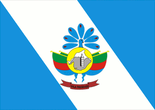 image by Dirk Schönberger, 5 April
2010
image by Dirk Schönberger, 5 April
2010
based on
http://www.vilapavao.es.gov.br/simbolos_hino/bandeira.htm
A descending white diagonal band on a light blue field, with the municipal arms centred.
Dirk Schönberger, 5 April 2010
The municipality of Vila Pavão (8,672 inhabitants in 2012; 433 sq. km) is
located in northern Espírito Santo, 270 km of Vitória. The town is surrounded
by high granite formations, locally known as "pedras", which make of Vila
Pavão one of the main granite extraction area in Brazil.
Vila Pavão
was settled in the 1920s by poor farmers emigrating from the dry hinterland
and by lumberjacks. They were joined in the 1940s by colonists from African,
Italian and Pomeranian origin. This second wave of colonization was allowed
by the building of a bridge on river Doce in Colatina and of a road from Nova
Venécia. The municipality of Vila Pavão was established on 1 July 1990,
seceding from Nova Venécia. The name of the place (lit., Peacock's Village)
recalls that the first hut build in what is today the downtown was known as
the Peacock's House, because it had its veranda decorated with a peacock
painting.
The flag of Vila Pavão is diagonally (pre bend) divided
blue-white-blue with an emblem, different of the municipal coat of arms, in
the middle. The flag was designed by Ronaldo Furtado de Oliveira (b.
1976), the winner of a public contest. Blue and white are the traditional
colors of Pomerania (see also
de-mv_.html#vpo), recalling the main origin
of the inhabitants of the municipality.
The rock represented on the
emblem to symbolize the granite rocks surrounding the town is known as the
Television Tower's Rock ( http://www.panoramio.com/photo/31275025 -
photo). The church tower, locally known as "Igrejona", belongs to the
Lutheran Evangelistic church of Vila Pavão. The tallest Lutheran tower in
South America and the tallest church tower in Espírito Santo, the "Igrejona"
is the emblem of the town (
http://www.seculodiario.com/turismo/turismo_03_08_2001.htm - photo). Here
it represents the religious faith of the inhabitants. The white map
represents the municipal territory. The yellow disk represents the sun
enlightening the municipal territory. Here it stands for a new day, light and
warmth required for life. The two flags flanking the disk are an
idealistic representation of the three main origins of the inhabitants, green
for the Italians, red for the Africans and blue for the Pomeranians. The
peacock represents the namesake of the municipality.
http://www.vilapavao.es.gov.br/index.php?option=com_content&view=category&id=56&Itemid=76 (new location)
Ivan Sache, 22 January 2012