
Last modified: 2012-02-11 by ian macdonald
Keywords: espírito santo | ponto belo |
Links: FOTW homepage |
search |
disclaimer and copyright |
write us |
mirrors
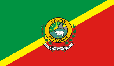 image by Dirk Schönberger,
30 March
2010
image by Dirk Schönberger,
30 March
2010
based on http://pt.wikipedia.org/wiki/Ponto_Belo
Diagonally divided green over red by a yellow bend sinister; municipal arms centerd.
Official website at
http://www.pontobelo.es.gov.br. The flag is shown at
http://www.pontobelo.es.gov.br/new/index.php?/Prefeitura/hino-bandeira-e-brasao.
Dirk Schönberger,
30 March 2010
The municipality of Ponto Belo (6,979 inhabitants in 2010; 356 sq. km) is
located in northern Espírito Santo, 350 km of Vitória.
Ponto Belo was
made a municipality by State Law No. 4,894 of 30 March 1994, seceding from
Mucurici. The municipality was inaugurated on 1 January 1997. The
municipality was named (lit. "Nice Point") from a small inn where the early
colonists, mostly involved in timber exploitation, went for lunch.
The
symbols of Ponto Belo are prescribed by Municipal Decree No. 107 of 29 April
1999. They were designed by students Eliseu de Aguilar Gonçalves and João Carlos Pinheiro dos Santo, winners of a public contest organized by the municipality.
Green represents a new municipality, aspiration to a better future; yellow is a
reference to the national flag, representing the resources of our country; red
represents the struggle and the blood shed for progress. On the coat of arms,
the coffee branch represents agriculture, the rising sun represents the
emergence of a new municipality, and the bovine represents cattle-breeding. The
municipal motto is "CRESCER E DESENVOLVER" (To grow and develop).
Ivan Sache, 21 January 2012