
Last modified: 2012-02-10 by ian macdonald
Keywords: bahia | rodelas |
Links: FOTW homepage |
search |
disclaimer and copyright |
write us |
mirrors
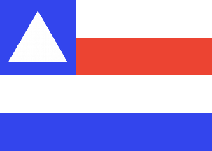 image by Dirk Schönberger,
17 February
2010
image by Dirk Schönberger,
17 February
2010
Based on http://pt.wikipedia.org/wiki/Rodelas
Four horizontal stripes, white-red-white-blue, a square blue canton with a white triangle.
Official website at http://www.rodelas.ba.gov.br, but no interesting information found; flag is shown on Wikipedia at http://pt.wikipedia.org/wiki/Rodelas.
Dirk Schönberger, 17 February 2010
The municipality of Rodelas (7,779 inhabitants in 2010; 2,575 sq. km) is
located in northern Bahia, on the border with Pernambuco, 460 km of Salvador.
The municipality was created by State Law of 30 July 1962. Rodelas was named
either for the native Francisco Rodelas or for the patella (Portuguese, "rótula")
used by the natives as a war trophy they extracted from the body of a killed
enemy.
Ivan Sache, 15 January 2012
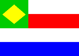 image by
Ivan Sache, 15 January 2012
image by
Ivan Sache, 15 January 2012
The flag shown, graphically, on the municipal website, differs
from the one still shown in Wikipedia. The canton is green with a yellow
lozenge instead of blue with a white triangle (that is, "Brazilian" rather
than "Bahian"). Whether it was changed to be more patriotic or to be more
distinct from the flag of Bahia (or for some completely different reason!) is
unknown to me.
http://www.rodelas.ba.gov.br/portal1/municipio/hino_brasao.asp?iIdMun=100129332
Ivan Sache, 15 January 2012