
Last modified: 2020-04-12 by rob raeside
Keywords: guyana | pomeroon-supenaam |
Links: FOTW homepage |
search |
disclaimer and copyright |
write us |
mirrors
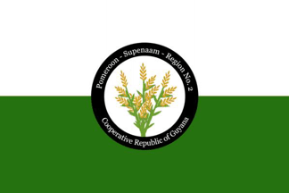 image located by Jason Saber, 7 June 2019
See also:
From "Emblems, Flags and Colours of the Regions of the Cooperative Republic
of Guyana", apparently published by the Government of Guyana.
Pomeroon-Supenaam - Region No. 2
The Pomeroon-Supenaam region comprises forested highland and low coastal plain,
but also takes in a small portion of the hilly sand and clay region. The 42,769
people of this region live in Amerindian settlements and more established
villages concentrated along the coast. The town of Anna Regina, on the west bank
of the Essequibo River, grew out of a government land development scheme and is
made up of former plantations such as Henrietta, Lima, La Belle Alliance. The
Tapakuma Project in this Region links the Tapakuma, Reliance and Capoey lakes
into one large conservancy, which supplies irrigation water for rice fields
which dominate Region Two. One of Guyana's largest rice producers, Kayman Sankar
Ltd operates in this region, producing rice not only for local consumption, but
also for export to other countries of the world. Besides rice farming, some
people cultivate coconuts and care for beef and dairy cattle. Timber production
is conducted on a very small scale in this region. Not surprisingly, the Region
is known as 'the Rice land'.
Jason Saber, 7 June 2019
The colours will represent the many waterways and the main economic activity;
rice farming. The symbol will be a rice stalk.
Jason Saber, 7 June 2019
 image located by Jens Pattke, 9 June 2019
Source:
https://demerarawaves.com