
Last modified: 2022-02-26 by rob raeside
Keywords: saint-rémi-de-tingwick | quebec |
Links: FOTW homepage |
search |
disclaimer and copyright |
write us |
mirrors
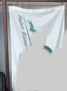
![[Saint-Rémi-de-Tingwick]](../images/c/ca-qcxrt.gif) image by Masao
Okazaki, 21 February 2022
image by Masao
Okazaki, 21 February 2022
based on photo
located by
Dave Fowler, 20 February 2022
The municipality of Saint-Rémi-de-Tingwick (474 inhabitants in 2011; 7,380
ha) is located 75 km east of Drummondville.
Saint-Rémi was first settled
in summer 1854 by Rémi Grenier, who was joined by another four colonists in
autumn of the same year. They were joined by their wives and children the next
spring. In 1881, priest Bellemare recorded 187 families paying the tithe.
The
parish of Saint-Rémi was established in 1881, formed of the eastern part of the
parish of Tingwick; a part of the province of Saint-Paul-de-Chester was added in
1883.
https://www.st-remi-de-tingwick.qc.ca
Municipal website
Ivan
Sache, 20 February 2022
Flag is a logo on white.
Dave Fowler, 20 February 2022
The logo was adopted in autumn 2012, replacing a more figurative one.
The
two blue lines represent the two watercourses located on each side of the
municipality: the Three Lakes and Nicolet River. They also represent the 10th
and 11th rangs that cross the municipal territory. The stripes are angled and
slightly diverging, being open to the future, to change and to developments.
The two curved lines represent the municipality's mountainous geography. The
green line evokes agriculture while the blue one evokes the Three Lakes.
The
small buildings symbolize the church, of particular architecture, and the
village.
https://www.st-remi-de-tingwick.qc.ca/explication-du-logo
Municipal
website
https://www.st-remi-de-tingwick.qc.ca/images/eglise-de-st-remi-de-tingwick
Photo of the church
Ivan Sache, 20 February 2022