
Last modified: 2021-12-11 by ian macdonald
Keywords: santa catarina | vargeão |
Links: FOTW homepage |
search |
disclaimer and copyright |
write us |
mirrors
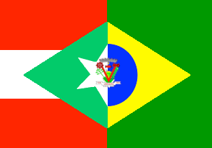 image by
Ivan Sache,
8 November 2021
image by
Ivan Sache,
8 November 2021
The municipality of Vargeão (3,569 inhabitants in 2020; 16,645 ha) is located
520 km north-west of Florianópolis.
Vargeão was established in 1938 by
colonists coming from Rio Grande do Sul on plots owned by the Colonizadora
Angelo De Carli and delimited by land surveyor Tomás Pitharka and local manager
Luiz Antoniutti, both from Joaçaba. The place was named for a floodplain ("várzea").
The first colonists were Fortunato Danielli and his sons, Jacinto and Mamante.
Their were soon joined by Isidoro Fiorini and his wife Helena, the first female
settler in Vargeão. Clearing was completed by the Berté, Piovezani, Camilotti,
Frozza, Basso, Pavan, Capelina, Assolini... families.
The district of Vargeão
was established, within the municipality of Faxinal dos Guedes, by Municipal Law
No. 24 promulgated on 16 February 1959, to be elevated a municipality by State
Law No. 954 promulgated on 16 March 1964, to be inaugurated on 21 April 1964.
https://www.vargeao.sc.gov.br/
Municipal website
Vargeão is located inside the southern rim of the Vargeão Dome, a large
circular depression described for the first time in 1978 during the 30th
Brazilian Geology Congress.
Vargeão Dome is one of the few astroblemes
found in the Brazilian territory. Located on the western part of Santa Catarina
State, this conspicuous circular depression has a diameter of 12 km and depicts
sharp topographic gradients of up to 150 meters between its borders and inner
portions. The circular feature seems today represent the erosion remnants of the
original impact crater, formed over volcanic rocks of the Serra Geral Formation
(Jurassic-Cretaceous) by the collision of a celestial body. In its interior,
this structure depicts a series of topographic elevations and depressions,
arranged as concentric rings, probably formed by faulting associated to the
crater formation process. The crater has a central uplift, comprising impact
breccias and sandstones from the Pirambóia/Botucatu (Triassic/Jurassic)
formations, which were vertically displaced by some 700 meters in comparison
with their normal stratigraphic position in this portion of the Paraná Basin.
Features due to impact metamorphism found at Vargeão include shatter cones in
sandstones and basalts, impact breccias comprising fragments of basalts and
sandstones and PDFs in quartz and plagioclase.
http://sigep.cprm.gov.br/sitio114/sitio114_impresso.pdf
Crósta, A.P.,
Kazzuo-Vieira, C., Choudhuri, A., Schrnak, A. 2005. Astroblema Domo de Vargeão,
SC. Registro de impacto meteorítico sobre rochas vulcânicas da Bacia do
Paraná. Sítios Geológicos e Paleontológicos do Brasil, 23-34.
Ivan Sache, 8 November 2021
A dimidiated design, using the base of the state flag (horizontal triband red-white-red, green lozenge, white star) and the base of the national flag (green field, yellow lozenge, blue disk), with the municipal shield over all in the centre.
Official website at
http://www.vargeao.sc.gov.br
Dirk Schönberger,
22 August 2012
The flag of Vargeão is prescribed by Municipal Law No. 168 promulgated on 9
November 1973.
Article 2.
The flag shall be designed as follows.
I
- Composition.
It shall be composed of a rectangle of 0.90 cm on 1.30 m,
charged with a lozenge equidistant of the rectangle's edge, from 0.10 m and
0.12 m, respectively. Left to the lozenge until its vertical axis, three
stripes of O.30 m placed parallel to its horizontal axis. A semi-circle and a
semi-star superimposed with the municipal coat of arms prescribed by Law No.
167 promulgated on 31 August 1973.
II - Colors.
The rectangle, divided
from left to right, shall include until the middle three stripes, two red and
one white in the center; from the middle to the end, a dark green field. The
lozenge shall be divided from left to right, sea green until the middle, then
golden yellow. The semi-star shall be white and the semi-circle light blue. The
colors of the coat of arms shall be green for yerba mate, the Brazilian pine
and forests; yellow for the sun, the maize plant and the chalice; red for the
"V", the tractor, symbolized industry and lettering; white for the hand, the
star, the host and the symbol of the district on a blue background.
Article 3.
The municipality's official colors are red symbolizing community
dynamism; white symbolizing peace and people's unity; green representing rich
and promising forest tree species; yellow as the symbol of plant diversity and
grains; blue as a symbol of the limpid sky and of admiration; and sea green as
a symbol of water.
The coat of arms of Vargeão is prescribed by
Municipal Law No. 167 promulgated on 31 August 1973.
Article 2.
The
coat of arms has the following symbolic meaning.
I - Welling up from the
star, which is the symbol of Santa Catarina state to which the municipality of
Vargeão belongs and on which the state is identified by its initials, a scroll
inscribed with the municipality's name and respective years of foundation and
emancipation.
II - Above it, a "V" composed of divergent lines running from
the center to the infinite, standing for "Vargeão", and also a perennial reward
to the Creator for the gift of the potential found in the area.
III - In
base of the "V", four yerba mate plants fully growing, faithfully highlighting
the boom of an industry with promising future and one of the municipality's
basic sources of income.
IV - Starting from the greening branches of yerba
mate, on the "V"'s right side, a fertile maize plant, productive and promising,
representing one of the main crops in the municipality supplied by a land that
demands little and offers a lot.
VI - Surmounting the maize plant, a tractor
symbolizing mechanized agriculture, new techniques and a new era for Vargeão's
economy. Progress actually reached the fields, with the blessing of the
Architect of the Universe, plenty will reign in the home of each hardworking
farmer.
VII - On the "V"'s left side, starting from the yerba mate plants, a
Brazilian pine, represented in a dynamic style, symbolizing industry, which is
represented above it. The Brazilian pine evokes a flourishing period and is now
threatened, but it is still abundant in the municipality and will be the main
industrialization factor for many years to come.
VIII - Inside the "V", an
extended area of mechanized cropping, which de facto indicates the possibility
of complete mechanization of agriculture. In the background, forests
symbolizing a rich, diverse, and fully exploitable resource. In the background,
a huge, glowing sun rising over the horizon, whose splendor highlights people's
warm confidence in the future and illuminates the community's darkest moments.
IX - Surmounting the "V", united, the symbols of agriculture and industry and
the ends of the "V" limiting the arable land, and a cheerful handshake. The
proper image of the union of people to reach common ideals, of the municipality
and of its authorities, all to the service of the community's highest
aspirations [...]
X - Above the hands, as a symbol of fraternity and
fraternization, a chalice, a host and a cross, surrounded by rays symbolizing a
spirit of vivid faith and highlighting the pacific and obedient character of
people who find in the faith and Christian spirit of their origin force
required to win all battles [...]
XI - Above, a crown representing the
district of Vargeão, its emancipation and autonomy among the other communities
of Santa Catarina and Brazil.
https://www.vargeao.sc.gov.br/cms/pagina/ver/codMapaItem/100865
Municipal website
Photos
https://www.facebook.com/municipiodevargeao/photos/1839571286093267
https://www.facebook.com/municipiodevargeao/photos/1894184020631993
Ivan Sache, 8 November 2021