
Last modified: 2012-03-17 by ian macdonald
Keywords: pará | parauapebas |
Links: FOTW homepage |
search |
disclaimer and copyright |
write us |
mirrors
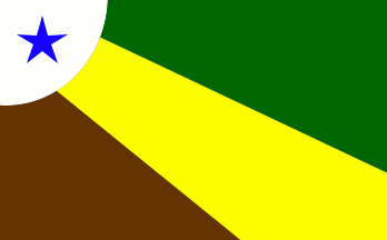 image by Dirk Schönberger,
11 February 2011
image by Dirk Schönberger,
11 February 2011
Based on:
http://www.parauapebas.pa.gov.br/index.php?option=com_content&view=article&id=96&Itemid=109
Three fields radiating from the upper hoist: green in the upper fly, yellow across toward the lower fly, maroon/brown in the lower hoist; and at the upper fly a white disk extending off the flag, overlain by a blue star.
Official website at
http://www.parauapebas.pa.gov.br
Dirk Schönberger,
11 February 2011
The municipality of Parauapebas (153,942 inhabitants in 2010; 7007 sq. km) is
located in southeastern Pará, 700 km of Belém. Parauapebas was founded in 1981
by the State-owned company "Companhia Vale do Rio Doce" in the framework of the
Carajás Iron project. The municipality of Parauapebas was established by State
Law No. 9,443 of 10 May 1988, seceding from Marabá. The town, located in one of
the richest mining regions in the world, mostly lives from iron, gold and
manganese extraction.
The flag of Parauapebas is prescribed by Law No. 29
of 10 May 1988.
http://www.parauapebas.pa.gov.br/index.php?option=com_content&view=article&id=96&Itemid=109
Ivan Sache, 9 February 2012