
Last modified: 2013-03-23 by ian macdonald
Keywords: sao paulo | alfredo marcondes |
Links: FOTW homepage |
search |
disclaimer and copyright |
write us |
mirrors
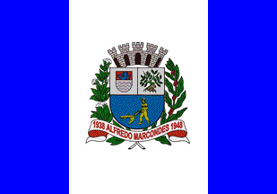 image by Ivan Sache,
4 March 2013
image by Ivan Sache,
4 March 2013
Alfredo Marcondes is named for its founder, Alfredo Soares Marcondes, who acquired on 24 December 1929 24. 2 ha of land located in the area known as Quilômetro 16, part of the municipality of Presidente Prudente. The district of Alfredo Marcondes was established by Decree No. 9,775 of 28 November 1938 and transferred to the municipality of Álvares Machado by Decree-Law No. 14,334 of 30 November 1944. The municipality of Alfredo Marcondes was established by Decree No. 233 of 24 December 1948.
The flag of Alfredo Marcondes is vertically divided blue-white-blue (1:2:1) with the municipal coat of arms in the middle.
Photos of the flag
http://www.alfredomarcondes.sp.gov.br/projeto-educacao-num-clique
http://picasaweb.google.com/lh/photo/cXXiOBrYwtfKoDmdECHdJg>
The coat of arms is "An English shield with a bordure argent, surmounted by a mural crown. On a field azure, attributes placed with harmony recall the history and features of the town and of the municipality. The shield is supported by branches of coffee and cotton, the two most important crops in the town".
http://camarapprudente.sp.gov.br/historia/hist_oeste/cidades/amarcondes/simbolos.html - "Enciclopédia Digital de Oeste Paulista" website
Ivan Sache, 4 March 2013