
Last modified: 2020-07-31 by ian macdonald
Keywords: rio grande do sul | muþum |
Links: FOTW homepage |
search |
disclaimer and copyright |
write us |
mirrors
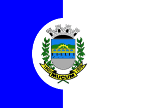 image by Ivan Sache, 31 July 2020
The municipality of Muþum (4,791 inhabitants in 2010; 10,900 ha) is located
150 km of Porto Alegre.
Muþum is first documented, as Mussum, in a record
of the rapids of river Taquari established in 1862 by the military engineer
Ant¶nio Augusto Arruda, Captain of the Brazilian Army. Incorporated on 11
December 1903 to the newly formed municipality of GuaporÚ, Muþum was renamed to
General Os¾rio, but the two names remained in use, even in official documents.
General Os¾rio was rather use to designate the town and Muþum to designate the
port.
The district of General Os¾rio was renamed to Mussum by State Decree
No. 7,589 issued on 29 November 1938. The municipality of Muþum was established
by State Law No. 3,729 promulgated on 10 July 1959.
https://mucum-rs.com.br/
Municipal
website
Ivan Sache,
31 July 2020
The flag and arms of Muþum are prescribed by Municipal Law No. 380
promulgated on 19 May 1975.
The flag has for colors blue and white, in
proportions 2/5 for blue, at hoist, and 3/5 for white, at fly, representing the
cult of Our Lady of Purification and the deep religious feelings of the first
inhabitants, and also a symbol of peace and harmony, the people's main ideals.
The two panels are equally charged with the municipal coat of arms.
The
flag was inaugurated on 28 May 1975 at the Municipal Chamber, during the
celebration of municipal emancipation and of the centenary of Italian
immigration in Rio Grande do Sul.
The coat of arms is composed of:
I.
A Ducal shield composed of three fields:
a) On top, azure, representing the
typical sky over the municipal territory, a cogwheel or, as a symbol of
industrialization of the settlement;
b) In the center, spanning over river
Taquari azure, a five-arched bridge or, representing the significance for the
municipality's development of road and rail traffic, connecting the town to the
rich and fertile region of Upper Taquari;
c) on bottom, argent, the
navigation's paper that made of Muþum the main warehouse for the colonies of the
highlands.
II. A scroll or inscribed at the ends with years "1905" and
"1959", respectively the dates of creation of the district and of municipal
emancipation, separated by the municipal toponym.
III. As supporters, green
branches of soybean, the municipality's main agricultural product.
IV. A
mural crown argent, composed of four towers representing the municipality's
political power.
https://mucum-rs.com.br/simbolos/
Municipal website
The emblem
features the road and railway Brochado da Rocha bridge, which yielded to Muþum
the title of "Princess of the Bridges". The bridge, of 289 m in length, was
erected at the end of the 1970s by the 1st Railway Battalion.
https://mucum-rs.com.br/turismo/
Municipal website
Photos
https://www.facebook.com/prefeituramucum/photos/a.407611592662576/2247829475307436/?type=3&theater
https://www.facebook.com/prefeituramucum/photos/a.407611592662576/2465743736849341/?type=3&theater
https://www.facebook.com/prefeituramucum/photos/a.407611592662576/2413184585438590/?type=3&theater
https://www.facebook.com/prefeituramucum/photos/a.407611592662576/1851742404916147/?type=3&theater
Ivan Sache,
31 July 2020
 image by Ivan Sache, 31 July 2020
 image by Ivan Sache, 31 July 2020
Ivan Sache, 31 July 2020