
Last modified: 2020-08-08 by ian macdonald
Keywords: rio grande do sul | santa bįrbara do sul |
Links: FOTW homepage |
search |
disclaimer and copyright |
write us |
mirrors
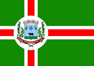 image by Ivan Sache, 4
August 2020
image by Ivan Sache, 4
August 2020
The municipality of Santa Bįrbara do Sul (8,829 inhabitants in 2010; 97,115
ha) is located 350 km north-west of Porto Alegre.
Santa Bįrbara do Sul
emerged along the old trail used by tropeiros to convey cattle to the Sorocaba
fairs. In 1820, Atanagildo Pinto Martins was granted a concession to establish
Fazenda Santa Bįrbara. The inauguration of the railway line in 1897 boosted the
development of the town.
In the 1950s, a group of farmers from Caxia do Sul,
supported by official grants, initiated wheat cropping in the municipality,
which soon ranked 5th among the wheat producers nationwide.
Santa Bįrbara was
renamed to Blau Nunes by Decree Law No. 270 issued in 1944, to be renamed to
Santa Bįrbara do Sul by Decree Law No. 39 issued on 4 September 1948. The
municipality of Santa Bįrbara do Sul was established by State Law No. 3,703
promulgated on 31 January 1959.
https://www.santabarbaradosul.rs.gov.br/
Municipal website
Ivan Sache, 4 August 2020
The flag of Santa Bįrbara do Sul is green, quartered by a white off-centered
cross filled red. A white disc is placed over the intersection of the arms of
the cross, charged with the municipal coat of arms.
Photos
https://www.facebook.com/prefsbsoficial/photos/a.1294409110737640/1294411704070714/?type=3&theater
https://www.facebook.com/prefsbsoficial/photos/a.560201347491757/1168441403334412/?type=3&theater
Ivan Sache, 4 August 2020