 klaus-michael schneider
Keywords: miranda | urdaneta | cua |
Links: FOTW homepage | search | disclaimer and copyright | write us | mirrors

Last modified: 2021-08-26 by  klaus-michael schneider
Keywords: miranda | urdaneta | cua |
Links: FOTW homepage |
search |
disclaimer and copyright |
write us |
mirrors
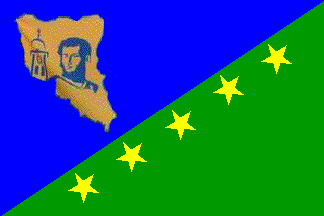
image by Ivan Sache, 21 September 2014
See also:
The municipality of Sucre (599,076 inhabitants in 2001; 672,447 [projection]
in 2014) is part of the Caracas Metropolitan Area. The municipality is made of
the five parishes of Petare (capital; 388,2662 inh. in 2001), La Dolorita
(64,864 inh.), Fila de Mariche (28,734 inh.), Caucagüita (55,123 inh.), and
Leoncio Martínez (62,093 inh.).
The territorial division of Venezuela, established in 1811, was maintained when
Gran Colombia was created (1819). The today's municipal territory of Sucre was
part of the Province of Caracas. Cantons were set up in 1821 by the Provincial
Assembly; the Canton of Petare, made of the parishes of Baruta and El Hatillo,
was established on 26 October 1822, with Lucas Amaya as its first Mayor. The
parishes of Monagas and Unión were established in 1853. The cantons were
transformed into departments in 1864. The same year, the State of Caracas, whose
capital was Petare, changed its name for State of Bolívar. Departments and
parishes were subsequently renamed districts and municipalities, respectively.
Accordingly, the District of Petare was made of the Municipalities of El
Hatillo, Libertad, Unión, and Monagas.
In 1879, the today's municipal territory of Sucre were transferred to the newly
created State of Centro, as part of the Territorial District of Pacheco.. In
1881, following the establishment of the State of Guzmán Blanco, Petare was the
capital of a Urban District, renamed Sucre on 22 September 1881. In 1891, the
District of Sucre was made of the Municipalities of Petare (capital), Monagas,
and Libertad. Incorporated in 1904 to the Federal District, the District of
Sucre was transferred back to the State of Miranda on 5 August 1909. The
District included the Municipalities of Monagas, Libertad, Unión, Petare, El
Hatillo, Baruta, Chacao, and Leoncio Martínez. Following the decentralization
reform set up in 1990, the District of Sucre was transformed into a
municipality. Baruta and El Hatillo were separated from Sucre, becoming
municipalities, too. So did Chacao in 1993.
The historical center of the municipality is Petare, established in 17 February
1621 by Captain Pedro Gutiérrez de Lugo and Father Gabriel de Mendoza, as the
village of Doctrina del Dulce Nombre de Jesús de Petare. The downtown is
registered as a National Cultural Good, the Dulce Nombre de Jesús church (1621;
https://www.flickr.com/photos/etxe-zuria/10029247805/in/photostream/) and
the Santa María Magdalena chapel (1785;
https://www.flickr.com/photos/etxe-zuria/9801932165/) being registered as
National Historical Monuments.
The painter Tito Salas (1887-1974) lived in the borough of El Toboso, part of
Petare. In 1911, Salas celebrated the centenary of the independence of Venezuela
with his famous "Tríptico
Bolivariano", portraying three critical events of Simón Bolívar's life. In
1970, he painted "Los
Causahabientes", representing the presidents of the republic in the 19th
century.
Source:
http://alcaldiamunicipiosucre.gob.ve/ - Municipal website
Ivan Sache, 21 September 2014
The flag of Sucre is divided into two blue and green triangles by the
ascending diagonal. Five ochre yellow stars are placed in the green triangle,
along the diagonal division. An ochre yellow map of the municipality, charged
with the clock tower of the Dulce Nombre de Jesús and the bust of General
Antonio José de Sucre, is placed the blue triangle.
The flag was adopted in the public contest "Una Bandera para mi Municipio" (A
Flag for my Municipality), pushed by the Municipal Chronicler, Coromoto Méndez,
and by the Municipal Councillor Darío Ramírez. The contest, approved on 10 June
2014 by the Municipal Council, was organized by the Network of Libraries of the
Directorate of Education of the Municipality of Sucre, supervized by the
Municipal Councillor Edmundo Rada, President of the Commission of Culture and
Tourism.
Pupils of the 5th and 6th classes of public and private schools of Sucre were
invited to submit flag proposals. In July 2014, a jury review the 47 proposals
submitted by pupils of 25 schools, and selected 10 of them, based on creativity,
symbolic, historical content, and combination and expressiveness of the colours.
The 10 selected proposals were produced in the cloth and submitted from 11
August to 6 September 2014 to popular vote in 25 places of the municipality. On
10 September, the municipality unveiled the winning proposal, designed by Ramsés
Arévalo, from the 5th class of Unidad Educativa Niño Jesús de Escuque (El
Llanito).
The blue triangle represent the rivers and ravines that water the municipality.
The green triangle represent the profuse vegetation of the municipality. The
yellow stars represent the five parishes that form the municipality. Ochre
yellow recalls the El Oro (lit., Gold) ravine that snaked through the village of
Dulce Nombre de Jesús de Petare.
Ivan Sache, 21 September 2014
Original proposal:
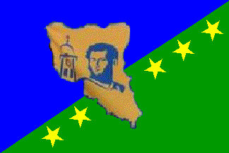
image by Ivan Sache, 21 September 2014
Finalist proposal:
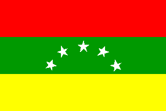
image by Ivan Sache, 21 September 2014
Finalist proposal, final version:
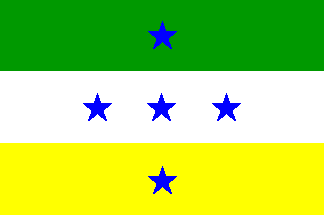
image by Ivan Sache, 21 September 2014
Finalist proposal, original version:
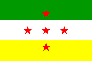
image by Ivan Sache, 21 September 2014
Finalist proposal:
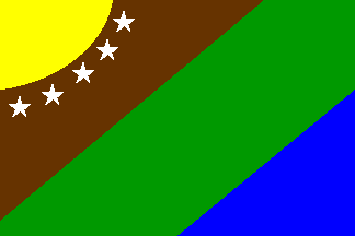
image by Ivan Sache, 21 September 2014
A video released by the municipality recapitulates the process - from the
early decision to have a contest to the selection of the 10 finalists. The video
offers at 7:31 a good view of the 10 selected designs.
Interestingly enough, as far as the winning proposal is concerned, there is a
notable difference between the design submitted to the first round of selection
and the design submitted to popular vote and eventually adopted. The original
proposal had a much bigger map, which extended through the green field and cut
the line of stars into two parts. I understand that the jury recommended some
modifications to the proposals before the production of flags in the cloth to be
presented to the public.
Three of the proposals include only coloured stripes and stars:
- a flag horizontally divided red-green-yellow with an arch of five white stars
on the green stripe, clearly inspired by the flags of Venezuela and of the State
of Miranda;
- a flag horizontally divided green-white-yellow with five red stars placed 1,
3, and 1 in the respective stripes. On the manufactured copy, the stars are
blue;
- a flag diagonally diagonally divided brown-green-blue with a yellow
quarter-of-sun in canton, lined with five white stars.
Sources:
http://www.eluniversal.com/caracas/140912/el-municipio-sucre-ya-tiene-su-bandera
- El Universal, 12 September 2014
http://www.el-nacional.com/deportes/Municipio-Sucre-Historia-eleccion-Bandera_0_478752132.html
- El Nacional, 7 September 2014
http://www.el-nacional.com/caracas/Hoy-escoger-bandera-Municipio-Sucre_0_478152208.html
- El Nacional, 6 September 2014
http://www.6topoderweb.com/2014/08/12/abren-votaciones-en-el-municipio-sucre-para-elegir-su-bandera/
- 6toPoder, 12 August 2014
https://www.youtube.com/watch?v=mxKetIrrr84 - Official video, 6 August 2014
http://www.caraotadigital.net/articledetail.asp?art=2344100 - Caraota
Digital, 16 July 2014
Ivan Sache, 21 September 2014