
Last modified: 2026-04-25 by rick wyatt
Keywords: national harbor | maryland | prince george's county |
Links: FOTW homepage |
search |
disclaimer and copyright |
write us |
mirrors
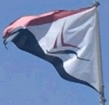
![[Flag of National Harbor]](../images/u/us-mdnhr.gif) image located by David Sigley, 23 May 2023
image located by David Sigley, 23 May 2023
based on photo
See also:
National Harbor is a census-designated place which was constructed in 2008,
and later given independent CDP status in 2010. It was previously a part of the
Oxon Hill CDP before it was given its own status.
The flag is a
horizontally divided field of red and blue with a white chevron pointing towards
the fly side of the flag. Inside the white chevron is the Sailboat used on the
community logo.
Google Streetview of the flag and the tenth anniversary flag:
https://www.google.com/maps
David Sigley, 23 May 2023
![[Logo of National Harbor]](../images/u/us-mdnhr-l.gif) image by David Sigley, 23 May 2023
image by David Sigley, 23 May 2023
The logo is made of a stylized red sailboat over blue waters. Underneath is
the community name in blue separated by a red line with a red star in the
center.
Source:
https://www.facebook.com/photo
David Sigley, 23 May 2023
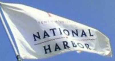
![[Tenth Anniversary Flag]](../images/u/us-mdnhr-10.gif) image by David Sigley, 23 May 2023
image by David Sigley, 23 May 2023
based on photo
The flag is a white field with the logo of the National Harbor Tenth
Anniversary logo in the center, which shows the number ten with the "0" being
replaced with a Ferris Wheel. Under the ten is the community name used from the
regular logo.
David Sigley, 23 May 2023