
Last modified: 2024-07-05 by daniel rentería
Keywords: orellana | aguarico | nuevo rocafuerte | tiputini | capitán augusto rivadeneira | santa maría de huiririma | cononaco | yasuni |
Links: FOTW homepage |
search |
disclaimer and copyright |
write us |
mirrors

image by António Martins-Tulálkin, 4 July 2024
see also:
The flag of canton of Aguarico (capital: Nuevo Rocafuerte) is
horizontally divided divided white-green.
Jens Pattke, 28 September 2008
The canton of Aguarico (4,847 inhabitants in 2010, 11,402.79 sq. km) is
located in the province of Orellana, in the wettest area of the Ecuadorian basin
of Amazon, on the border with Peru.
In the first Law on Territorial Division of the Republic of Ecuador, adopted on
29 May 1861 by the National Convention, the village of San Miguel del Aguarico
was incorporated to the canton of Napo (province of Oriente); in the third Law
on Territorial Division, adopted in 1878, the village, renamed Aguarico, was
incorporated to the territory of Napo (region Oriental). The Law of 1864 lists
Yasuní as part of the territory of Napo. The Law of 1897 lists Tiputini as part
of the territory of Napo. In 1911, President Víctor Emilio Estrada divided the
province of Oriente into five cantons: Aguarico (Rocafuerte) was the capital of
the canton of Napo.
On 19 August 1925 (Official Register No. 33), the region Oriental was divided
into the provinces of Napo-Pastaza and Santiago Zamora. The canton of Aguarico
was established, as part of the province of Napo-Pastaza and including the
villages of La Coca (capital), Loreto, Rocafuerte, Yasuní, and Cononaco. The
Oriente Special Law, adopted in 1960, stated in Article 2 § 4 that the canton of
Aguarico included the villages of Rocafuerte (capital), Yasuní, Cononaco, and
Francisco de Orellana. The Law was amended in 1960, establishing the province of
Napo, which included the canton of Aguarico. On 30 April 1969 (Official Register
No. 169), Francisco de Orellana was established as a canton, while the parishes
of Cuyabeno, Santa María de Huiririma, Capitán Augusto Rivadeneira, and Tiputini
were created within the canton of Aguarico; the capital was listed as Nuevo
Rocafuerte. The canton of Aguarico was eventually incorporated on 30 July 1998 (Official
Register No. 372) to the newly established province of Orellana.
The canton of Aguarico is divided into the two urban parishes of Tiputini and
Nuevo Rocafuerte and the four rural parishes of Capitán Augusto Rivadeneira,
Santa María de Huiririma, Cononaco, and Yasuní. The capital of the canton was
originally located in Nuevo Rocafuerte. On 8 September 2001, Mayor Franklin Cox
Sanmiguel (b. 1962 in Nuevo Rocafuerte; elected Mayor in 2000 and re-elected
three times since then) was expelled from Nuevo Rocafuerte by revolted villagers,
who stormed the municipal buildings, material, and archives. As a retaliation,
Cox relocated the next day the cantonal administration to Tiputini; the new
capital was confirmed after a referendum organized on 8 June 2008.
The flag of Aguarico is horizontally divided white-green. White is the vivid
representation of the purity of the cultural identity of the peaceful
inhabitants of the area. Green is a symbol of the immense primary forest of the
Amazon basin, of the border, and of the mysticism of a village located at the
gate of the Amazon basin.
Source:
http://www.aguarico.gob.ec/gadaguarico/index.php/2013-05-17-13-47-14/2013-05-17-14-42-55
- Canton website
Ivan Sache, 28 October 2014
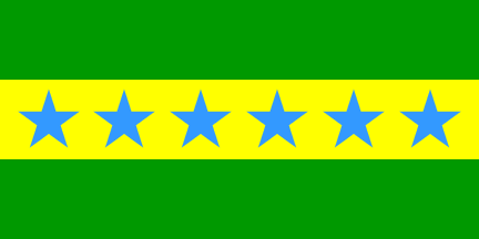
image by António Martins-Tulálkin, 4 July 2024
The parish of Tiputini (1,433 inhabitants in 2011, 588 sq. km) is located in
the basin of river Napo, on the banks of river Tiputini. Established on 30 April
1969 (Official Register No. 169), the parish of Tiputini was declared an urban
parish on 5 December 2011 (Official Register, No. 590).
The parish is made of the communities of Tiputini (capital), Vicente Salazar,
San Carlos, Boca Tiputini, Pandochita, Puerto Miranda, Yana Yacu, Patas Urcu,
and Llanchama.
The flag of Tiputini is horizontally divided green-yellow-green with six blue
stars placed horizontally in the yellow stripe. Green represents the forest
while yellow represents the resources of the soil. The stars represent the six
most important settlements in the parish.
Source:
http://www.aguarico.gob.ec/gadaguarico/index.php/2012-10-01-19-49-35/2013-05-17-13-58-22/2013-05-17-14-23-38/2-uncategorised/32-tiputini
- Parish page on the canton's website
Ivan Sache, 28 October 2014
The parish of Nuevo Rocafuerte (1,641 sq. km) was established on 22 January
1945 to relocate the inhabitants of Rocafuerte (Cabo Pantoja), a village
destroyed by the Peruvian forces during the War of '41 (5-31 July 1941).
The parish is made of the communities of Nuevo Rocafuerte (capital), Alta
Florencia, Santa Rosa, Santa Teresita, and Bello Horizonte. Nuevo Rocafuerte is
known as the Ecuadorian "ultimate village", being located on the border with
Peru.
There is no report of the flag of Nuevo Rocafuerte
Source:
http://www.aguarico.gob.ec/gadaguarico/index.php/2012-10-01-19-49-35/2013-05-17-13-58-22/2013-05-17-14-23-38/2-uncategorised/31-nuevo-rocafuerte
- Parish page on the canton's website
Ivan Sache, 28 October 2014
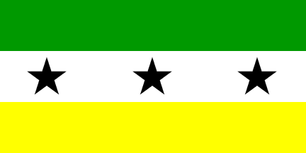
image by António Martins-Tulálkin, 4 July 2024
The parish of Capitán Augusto Rivadeneira (1,089 inhabitants in 2011; 917 sq.
km) was established on 30 April 1969 (Official Register, No. 169). The parish is
made of the communities of Chiru Isla (capital), Samona, Sinchi Chikta, and
Limón Yaku.
The flag of Capitán Augusto Rivadeneira is horizontally divided
green-white-yellow with three black stars placed horizontally in the white
stripe. Green represents the forest flora, white represents the people's peace
and tranquillity, and yellow represents the people's resources and culture. The
stars represent the three communities in the parish; black represents oil
extraction.
Source:
http://www.aguarico.gob.ec/gadaguarico/index.php/2012-10-01-19-49-35/2013-05-17-13-58-22/2013-05-17-14-23-38/2-uncategorised/33-cap-augusto-rivadeneira
- Parish page on the canton's website
Ivan Sache, 28 October 2014

image by António Martins-Tuválkin, 4 July 2024
The parish of Santa María de Huiririma (610 inhabitants in 2011; 583 sq. km),
part of the canton of Aguarico (province of Orellana), was established on 30
April 1969 (Official Register, No. 169). The rural parish of Santa María de
Huiririma is made of the communities of Puerto Quinche, Huiririma, San Vicente,
and Centro Ocaya.
The flag of Santa María de Huiririma is horizontally divided blue-white-green.
Blue represents river Napo, white represents the people's purity and
tranquillity, and green represents hope and exuberant vegetation.
Source:
http://www.aguarico.gob.ec/gadaguarico/index.php/2012-10-01-19-49-35/2013-05-17-13-58-22/2013-05-17-14-23-38/2-uncategorised/34-santa-maria-de-huiririma
- Parish page on the canton's website
Ivan Sache, 28 October 2014
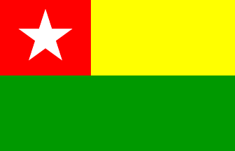
image by António Martins-Tuválkin, 4 July 2024
The parish of Cononaco (791 inhabitants in 2011, 1,550 sq. km) is located at
the heart of the Yasuní National Park, on the border with Peru. Most, if not all,
of the inhabitants belong to the Waorani Nation. Established on 19 August 1925 (Official
Register No. 33), the parish is made of the communities of Kawymeno (capital),
Dikaro, Yarentaro, and Bameno.
The flag of Cononaco is horizontally divided yellow-green, with a red canton
charged with a white star.
Source:
http://www.aguarico.gob.ec/gadaguarico/index.php/2012-10-01-19-49-35/2013-05-17-13-58-22/2013-05-17-14-23-38/2-uncategorised/35-cononaco
- Parish page on the canton's website
Ivan Sache, 28 October 2014

image by António Martins-Tuválkin, 4 July 2024
The parish of Yasuní (251 inhabitants in 2011; 844 sq. km) is located in the
basin of river Aguarico, on the border with Peru. Established on 19 August 1925
(Official Register No. 33), the parish is made of the communities of Zancudo
Cocha (capital), Fronteras del Ecuador (lit., Borders of Ecuador), and Martinica.
The flag of Yasuní is horizontally divided blue-green. Blue represents river
Aguarico while green represents the forest.
Source:
http://www.aguarico.gob.ec/gadaguarico/index.php/2012-10-01-19-49-35/2013-05-17-13-58-22/2013-05-17-14-23-38/2-uncategorised/36-yasuni
- Parish page on the canton's website
Ivan Sache, 28 October 2014