
Last modified: 2020-06-20 by rob raeside
Keywords: beauharnois | quebec |
Links: FOTW homepage |
search |
disclaimer and copyright |
write us |
mirrors
![[Beauharnois flag]](../images/c/ca-qcbhr2.gif) image
by Olivier Touzeau, 25 September 2013
image
by Olivier Touzeau, 25 September 2013
See also:
The town of Beauharnois (12,175 inhabitants in 2013; 6,909 ha) is located
in Beauharnois-Salaberry Regional County Municipality, Region Montérégie. The
town is part of Greater Montreal Area.
Beauharnois is named for Charles
de Beauharnois (1671-1749), Governor of Nouvelle-France (1726-1747). In 1729,
Charles de Beauharnois and his brother Claude were granted by King Louis XV
the domain of Villechauve, a huge territory limited in the north by river
Saint-Laurent and in the south by the today's border with the USA. In 1795,
Michel Chartier de Lotbiničre sold the domain to Alexander Ellice, a Scottish
trader, whose family would rule the place for three generations. The young
lord Edward Ellice was jailed in 1838 during the second Patriots' uprising.
His wife Jane wrote a famous diary and painted scenes of the uprising,
including the famous "The Insurgents at Beauharnois". After the suppression of
the uprising, 10 men of Beauharnois were deported to Australia.
The
civil parish of Beauharnois was erected in 1835, while the village of
Beauharnois was established in 1846. The town of Beauharnois was incorporated
in 1863. The today's town of Beauharnois was formed on 1 February 2002 as the
merger of the former towns of Beauharnois, Maple Grove and Melocheville. The
Beauharnois power plant, built on the Beauharnois Canal in three stages from
1929 to 1961, was one of the longest river plants in the world and remained
the most powerful in Québec until the late 1970s.
http://ville.beauharnois.qc.ca -
Municipal website
Ivan Sache, 14 September 2013
A newer logo has been adopted in 2016. The current flag is light blue with
the graphic part of the logo on white:
https://ville.beauharnois.qc.ca/wp-content/uploads/2020/04/IMG_6608.jpg
https://www.google.com/maps
Olivier Touzeau, 25 May 2020
![[Beauharnois flag]](../images/c/ca-qcbhr1.gif) image
by Olivier Touzeau, 25 September 2013
image
by Olivier Touzeau, 25 September 2013
There is a newer municipal flag in use in Beauharnois since approximately
2013. It appears to be white over green, divided by a green vector in a shape
similar to what is in the old logo flag. The city logo is on the blue portion in
white.
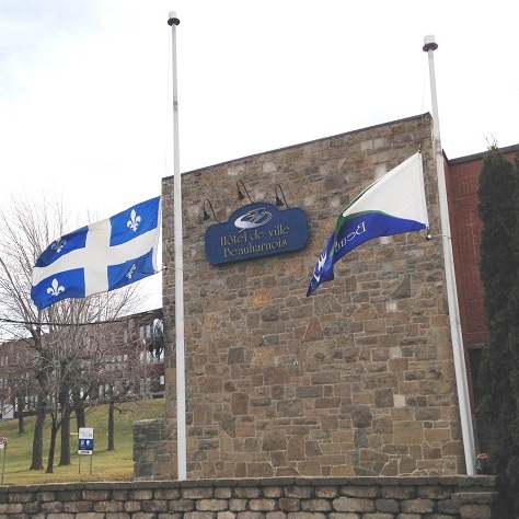
https://www.infosuroit.com/wp-content/uploads/2013/12/Beauharnois-drapeaux-en-berne-en-hommage-a-Nelson-Mandela-Photo-courtoisie-pour-INFOSuroit.jpg
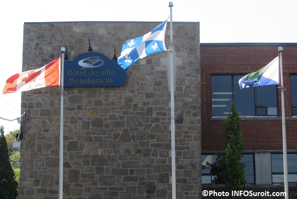
https://www.infosuroit.com/wp-content/uploads/2014/09/Hotel-de-ville-Beauharnois-avec-drapeaux-Photo-INFOSuroit_com.jpg
Logo:
https://www.infosuroit.com/wp-content/uploads/2016/03/logo-2016-ville-de-beauharnois-visuel-courtoisie-pour-infosuroit.jpg
Dave Fowler, 22 May 2020
The flag described by Dave was in use between about 2013 and 2016
More images:
https://www.google.com/
Olivier Touzeau, 25 May 2020
![[Beauharnois flag]](../images/c/ca-qcbhr.gif) image
by Olivier Touzeau, 25 May 2020
image
by Olivier Touzeau, 25 May 2020
The flag of Beauharnois is white with the town's logo
in the middle. The flag was hoisted on 3 August 2012 on USS Hurricane, USS
DeWert and HMCS Ville du Québec during the celebration of the 200th
anniversary of the War of 1812.
http://www.infosuroit.com/belle-aventure-pour-le-drapeau-de-la-ville-de-beauharnois
- "INFOSuroit", 4 August 2012
The two blue and green elements placed
inside a blue circle symbolize the merging of the former municipalities of
Beauharnois, Maple Grove and Melocheville. They also represent boats sailing
on lake Saint-Louis, birds and freedom. The merging of the two elements form
the letter "B", for "Beauharnois". The light blue, roundish element symbolizes
the banks of lake Saint-Louis that border the municipality all over its
length. Inside the roundish element, a white shape symbolizes a leaf,
recalling the natural environment and its beauty, the Robert wood*, the Québec
Archaeology Museum at Pointe-du-Buisson**, and Îles-de-la- Paix***. The
typographical shape of the name "Beauharnois" recalls the rich history of the
town.
http://ville.beauharnois.qc.ca/mairie/signification-du-logo - Town's
website
*The Robert wood features one of the most diversified floras in
eastern Canada, with more than 25 tree species and 350 herbaceous plants.
**Founded in 1986, the Museum is made of 17 forest archaeological sites, where
more than 2 million artefacts were excavated.
http://ville.beauharnois.qc.ca/decouvrir-beauharnois/attraits-touristiques
*** Îles-de-la-Paix (Peace Islands) archipelago, located in the southwest
part of Lake Saint-Louis, is a national reserve of wildlife and a refuge of
migrating birds, owned by the Canadian Wildlife Service
http://www.ilesdelapaix.ca
Ivan Sache, 14 September 2013
This white flag with logo was in use in front of the city hall before 2013:
https://www.google.com/maps/
Olivier Touzeau, 25 May 2020