
Last modified: 2021-06-05 by rob raeside
Keywords: qualicum beach | british columbia | fish | maple leaf | teepee |
Links: FOTW homepage |
search |
disclaimer and copyright |
write us |
mirrors
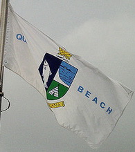
![[Pemberton flag]](../images/c/ca-bc-qb.gif) image by Masao Okazaki,
3 May 2021
image by Masao Okazaki,
3 May 2021
based on
photo contributed by Valentin
Poposki, 15 January 2008
See also:
Outside Links
Qualicum Beach is a town located in the Regional District of Nanaimo, British Columbia. As of the 2006 census, the town had a total population of 8,502.
Located on the Strait of Georgia on the eastern coast of Vancouver Island in the shadow of Mount Arrowsmith, the community has been a popular tourist destination for residents of Victoria and Vancouver as well as a retirement community. It is served by the Island Highway (the main North-South highway on the Island) and by a daily train. The community is dotted with rental cottages along the coastline. It has the oldest average population in Canada.
Qualicum Beach is frequently, although informally, grouped as a twin city with the neighbouring city of Parksville.
A photo of the flag can be seen at the
Waymarking website.
Valentin Poposki, 15 January 2008
To draw the flag I downloaded the coat of arms of the town's own making from
Wikipedia and revised the colors and details to match the photo from
Waymarking posted above.
Masao Okazaki, 3 May 2021